
3D2N Kelantan Hiking Trip : Gua Gelap - Pagar - Keris & Gunung Baha - Ayam - Stong

I first heard of Gunung Stong back in 2016, when a friend suggesting climbing it due to the beautiful Jelawang waterfall. Unfortunately, the plan never went through as it was towards the end of the year and that the mountain was closed temporarily due to raining season. I later found out that the mountain can be conquered together with two other mountains in proximity – Baha and Ayam. Together the hike is named “BAS” (Baha – Ayam – Stong).
After having a great time with Peaks Outdoor in CBL last April, I suggested another camping trip to these three mountains which are located in Gunung Stong State Park (previously known as Jelawang Jungle), Kelantan. A date was set in July but due to family commitment, I had to bail out from the said trip. (Sorry guys!). Chin organised a similar event in August, but I originally had no intention of joining since it was just several days away from my Phatthalung trip, as I figured I would overexert myself from traveling to and from Singapore. However, two weeks before the trip, I was overwhelmed by stress at work and was dying to get some fresh air. I had heard that the event was still open for registration and I signed up after securing my flight ticket.
To the mountains we went, where the view the great, the air is fresh, the head is light, the mind is clear, the body is loose, and the soul is free
I was previously told that BAS is a leisure hike and suitable even for beginner, so I went and recruited my ex-colleague, Dominic who had started hiking not too long ago. Little do we know that we had underestimated these mountains.
**Disclaimer:
Dominic is a total newbie in hiking at the time of this hike. He had only hiked Bukit Beruang in Melaka and Gunung Brinchang in Cameron Highlands, which in comparison to BAS is a whole different level. For those who had more experience in hiking (say, at least Gunung Nuang), BAS isn't that difficult. For experienced hikers, BAS is pretty easy.
 |
| The 9 peaks of Jelawang |
Other mountains in Gunung Stong State Park:
1. Gunung Tera 1556m
2. Gunung Che Tahir 1430m
3. Gunung Beirut 1380m
4. Gunung Nyelit 1345m
5. Gunung Saji 1285m
6. Gunung Kob 1240m
Day 1: Cave exploration day
 |
| Kompleks Gua Ikan |
As Kelantan is several hours away from KL, a bus was arranged for (approximately) 40 of us. Similar to our Chamah trip, we gathered at MRR2 Starbucks at 11pm, and left around midnight, headed towards Gua Musang. We reached Gua Musang at around 4am but everyone was still sleeping soundly. Since the breakfast place has yet to open, we continued our much-needed sleep in the bus until 7am. After breakfast, we continued our journey to Dabong. We finally arrived at Kompleks Gua Ikan at 11.30am, where some hikers (who drove from KL) had already arrived.
 |
| Photo credit: Chin |
After a short briefing by our three guides – Baha, Jay and Woo, we crossed the road to the other side, where we entered the caves, officially starting our caving adventure.
 |
| Let's start |
Gua Gelap
 |
| Gua Gelap |
 |
| Photo credit: Chin |
 |
| Photo credit: Chin |
Being one of the few at the frontier, Mj and I exited the cave first, and there was where the sign of the cave is located. Since the passage to get through is small and narrow, it took approximately 45 minutes for everyone to finally gather at the exit, before proceeding to the next cave – Gua Pagar.
 |
| Sign of Gua Gelap at the exit |
Gua Pagar
About a stone’s throw away from the exit of Gua Gelap, lies an entrance to another bigger cave – Gua Pagar. “Pagar” literally means “fence” in Malay, but unfortunately, I do not why it is named so. Right in front of the entrance, was a rock formation which resembles a monkey’s head, hence the name “Monkey Head Stone”.
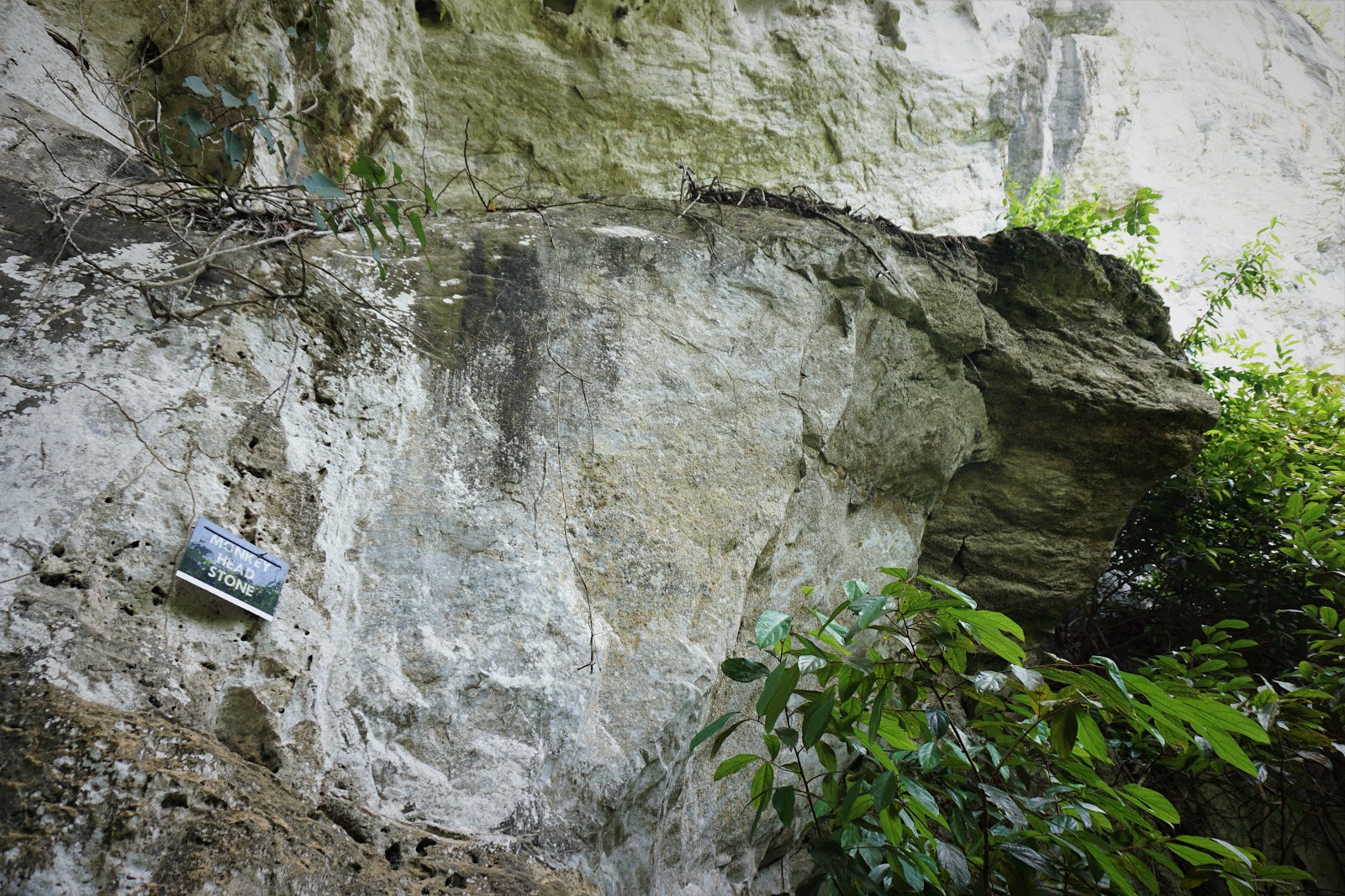 |
| Monkey Head Stone |
 |
| Gua Pagar |
Compared to Gua Gelap, Gua Pagar is much bigger in size, and more interesting. We spent a good 40 minutes in this caves as there were several interesting spots for photo shooting. Luckily I brought my camera along which works well under low light condition. Here’s some of my personal favourite:


Gua Keris
To go to Gua Keris, we walked out from Gua Pagar’s entrance and turned right. It’s about 10 minutes away, where we need to climb and crawl a little before finally reaching Gua Keris.
 |
| Gua Keris |
You would probably realise now that all the caves’ name is in Malay and there is no exception to Gua Keris. “Keris” is actually an asymmetrical dagger used by Malay warrior, and the cave is named so, after a stalagmite formation which resembles this traditional weapon.
 |
| Keris-shape stalagmite |
Compared to Gua Pagar, Gua Keris is bigger in size (but less interesting) and as we ventured deeper inside, it became darker that we needed to switch on our headlights. Here’s some of the shots for the day:
 |
| Gua Keris entrance |
 |
| stack of stones |
 |
| Photo credit: Chin |
We left Gua Keris following the same way we entered, and re-entered Gua Pagar, where we walked out from another exit. This brought us to the main road, where we walked back towards our bus, and headed over to a Malay food court for lunch.
Kem Baha
It was already 2.30pm by the time we left Kompleks Gua Ikan, and we had late lunch at a Malay foodcourt. We then reached Gunung Stong State Park at 4pm. After reorganising our bags and a short briefing by the guides, we took a group photo and started our ascent to the campsite – Kem Baha.
 |
| Photo credit: E.C. Choi |
The hike to Kem Baha from trailhead is only about 2km. Considering it’s such a short distance, I left Dominic to hike by his own while I rushed ahead to get a good spot at the campsite (tent 1 – MJ, Kai Sin and I, and tent 2 – Seung Fei and Terry). Wanting to join the two tents side by side, we would need a bigger space, and hence it’s better to hike faster, in order to secure a good spot.
 |
| Bridge crossing |
 |
| Photo credit: Choi |
Don’t judge a book by its cover. Don’t judge a mountain by its distance
 |
| Reached Kem Baha with Tracy and Uncle Mak |
Thankfully, I reached Kem Baha in an hour time but was told that the guide had reserved a section of the campsite for 47 of us. However, as we were unsure where it is, we would have to wait for him to bring us there. By the time we were brought to our designated campsite, many good spots were already snatched by those walking in front of me. In the end, the spot I took was a lowland. I can tell from the Seung Fei’s face that it’ a lousy spot. Oops! And true enough, that night, disaster struck.
 |
| Photo credit: E.C. Choi |
Unlike many other mountains I’ve been, Kem Baha is well facilitated with a toilet, so you do not need to settle your business among the bushes.
 |
| Public toilet at campsite |
As for water source, there’s a river and waterfall next to the campsite, but you would need to hike and climb a little to get to it. And that’s what I hated most about this campsite. It’s such a hassle to go wash ourselves, and by the time we are clean, we risk dirtying ourselves again as we climb up to the campsite.
 |
| River and waterfall (Photo credit: Chin) |
 |
| Waterfall (Photo credit: Edison) |
The water is clean and edible, but if you are worried, you may always use a filter. Be sure to head downstream to do your washing, so that you don’t pollute the water someone is filling up to drink.
 |
| Convenient store |
At the right of the entrance of Kem Baha, is also a convenience store selling snacks and drinks. The price is on a higher note though, but considering the effort to carry it up, I’d say it’s worth what you’re paying for.
Straight ahead from the entrance, about a few hundred metres away is a cliff facing the east, which is a perfect spot for sunrise. Every morning, hikers would be gathered there for sunrise.
Luxurious dinner
Our dinner that night was exceptionally luxurious. Both KK and Uncle Mak were experimenting new dishes, and we’ve got fried fish from Uncle Mak and thai-style steamed fish from KK’s kitchen. Apart from that, we also had stir-fry romaine lettuce with fermented beancurd and herbal steamed chicken. Steven also brought his homemade braised pork which completes our dinner for the night. Thanks guys! I was well-fed, and the dinner was amazing!
 |
| Thai-style steamed fish by KK |
 |
| Braised pork by Steven |
 |
| Fried fish by Uncle Mak |
 |
| Stir-fry romaine lettuce with fermented beancurd |
 |
| Herbal steamed chicken |
By the time we went to bed that night, it was raining cats and dogs and unfortunately, our tents were soaked as rain seeped in. Our tents were set at lowland and rain water flowed towards our direction, flooding our tent. Thankfully, Kai Sin and the guys had got air mattress (I should get one of those) to save them from this disaster. Though Mj has gotten a layer of sleeping mat underneath her sleeping bag, it also got wet, while I was in the direst situation since I had no air mattress or sleeping mat. As a desperate measure, I decided to save my upper body at the least, and proposed to lay my head next to MJ’s feet, so that part of my upper body is at least saved from the rain water. With that, we fell asleep under the sound of pouring rain.
Day 2: Not a leisure day hike
Sunrise
We woke up at 5.30 the next day to the sound of Uncle Mak busying himself in the kitchen, preparing lunch for the day. While Kai Sin prepared French toast for breakfast, I helped chopped garlics for our fried beehoon (lunch). In no time, both breakfast and lunch were ready, and with breakfast on our hands, we walked towards the sunrise spot.
 |
| No sunrise, only sea of clouds (Photo credit: Chin) |
 |
| With national flag |
On a day with good weather, one could see not only sunrise, but a clear sight of Gunung Chamah. We did manage to spot Gunung Chamah for a moment before the sea of clouds block our view, but there was no “egg yolk” sunrise that day. It was just unfortunately too cloudy.
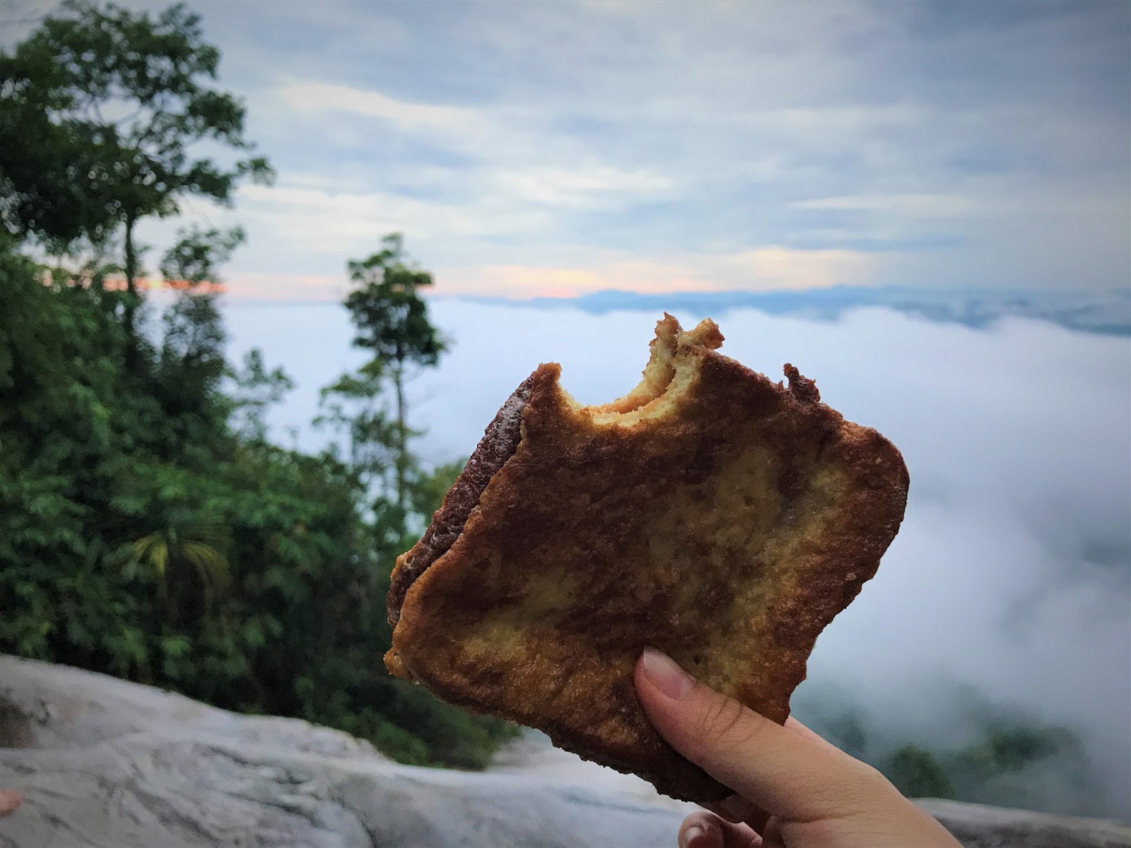 |
| French toast (Photo credit: Dominic) |
 |
| Creme brulee by Kai Sin |
With no luck on our side, we return to the campsite to pack our hiking bag and gear. At 8.45am, all but 7 hikers (they decided to chill at campsite instead of going ahead with the strenuous 10-12 hours hike) gathered at the Kem Baha entrance for a short briefing before we started our ascent to the first mountain – Gunung Baha.
 |
| Photo credit: E.C. Choi |
Baha
The route to Baha peak is full of steep ascent all the way from campsite to Baha peak. Along the way, there are two rivers to cross – Sungai Rantai and Sungai Baha.
 |
| Sungai Rantai |
 |
| At Sungai Rantai (Photo credit: Chin) |
 |
| Sungai Baha (Photo credit: Choi) |
As Dominic was new to hiking, I accompanied him throughout the hike, making sure to keep an eye on him. He was doing great for the first few hours, being able to keep up to the rest of the time, but as we hiked further and further, he began to take slower and slower steps, and his breathing started to get heavier and heavier.


About an hour away from Baha peak, his legs started to cramp. Thankfully, he’s prepared oral salt to be consumed in such situation, and a hiker from Kuala Lipis we encountered along the way offered us some cramp reliever spray. With Dominic’s condition, the gap between us and the rest of the hikers started to widen.


For someone who has always been hiking at my own pace (which is consider fast-paced), slowing down my pace by almost half isn’t an easy feat. There were times when I wanted to abandon him and hiked with my own pace, but I can’t possibly leave him behind after “tricking” him into joining this trip, so I stayed and tried to sweep and pace him the best I can.
Never leave a man behind


I found it difficult to walk behind him, so I walked in front of him, keeping a distance of several feet away, but constantly turned back and checked on him. It's formally my first time being a sweeper, and it's a test of patience. Luckily, by 12.40pm, we reached our first peak of the day – Gunung Baha, just in time for lunch.
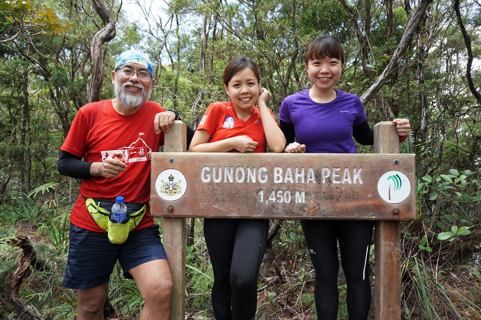 |
| With Uncle Mak and MJ |
 |
| With Dominic |
The fastest hikers had arrived an hour before us, and by the time we settled down for lunch, they moved on to the next mountain peak – Ayam. Not wanting to waste too much time resting, as our muscles may cool down and hence making it more difficult to warm up again, we proceeded to Ayam peak after resting for 20 minutes.
Ayam
The journey from Baha to Ayam is a rather short one. The hike was also relatively easier as compared to Baha, as the trail was less steep. After descending from Baha, we reached Junction Ayam – Stong, where the path diverged into two. This is where most hikers get lost. That is why it is important to hike with a guide to avoid getting lost in the mountain.
The left route leads to Gunung Stong, while the right one leads to Ayam. There’s a water source not far away from the junction. Finally at 1.45pm, we reached Ayam peak.
 |
| Photo credit: Edison |
After snapping a quick photo and taking a 5 minutes break, we descended to Junction Ayam – Stong again, where we took the other path to Stong.
Tip: This is the last chance to fill up your water as the journey to Stong and back to campsite will be a long one.
From Junction Ayam – Stong onwards, Dominic’s body started to give in to exhaustion. Eventually, we were left behind, far behind the rest of the team. Accompanied by Mr. Baha (sweeper-guide), we ascended slowly towards Stong.
Stong
After what seemed like forever, we reached Gunung Stong at 3.45pm. Since we were the last to reach, the other hikers had waited for (possibly) an hour or so. After a big welcome by the rest, we took a group photo together, before descending to Kem Baha.
 |
| Photo credit: E.C. Choi |
The way down to Kem Baha is steeper than the way up, with lots of tree roots (my favourite kind). Descending via this trail works best for experience hikers as it is usually faster. However, for inexperienced hiker like Dominic, it’s hard on the legs. This reminded me of my Tahan trip, where I took longer hours to descend.
It’s a different way from where we ascended, but the path cut through before Sungai Rantai. Thus, there was only one river crossing on our way back to Kem Baha.
 |
| Permatang Bonsai |
As we trekked in thick rainforest, there was no view, but along the way we passed by several sights – Permatang Bonsai, “Raja Duduk Hamba Berlutut” Stone and fallen tree bridge.
 |
| Raja Duduk Hamba Berlutut |
There’s even a cave called Gua Kubur (literally means “grave”), according Chin. Sadly, Dominic and I never saw this cave during our descent. We could have probably passed this place while pressured to get back to campsite before it rained.
 |
| Gua Kubur (Photo credit: Chin) |
 |
| Gua Kubur (Photo credit: Chin) |
It’s not unusual to rain in the late afternoon in Malaysia jungle, and by 5.45pm, it started to rain. Thankfully, we managed to cross Sungai Rantai before the tide rose and risked being trapped at the river bank.
 |
| Fallen tree bridge |
We finally reached Kem Baha at 7pm, all soaked and wet, but satisfied that we made it within the estimated cut off time. I was expecting to hike several hours more than that, so Dominic actually did a pretty good job for a newbie. And the best part? He didn’t complain at all and endured the cramps on his throughout the entire hike and didn't give up.
We may be the last to reach the summit and to return to the campsite, but I was proud of him. Not only that he wasn't frightened by the entire experience, he even vowed to train harder for future hikes.
Rainy night
The heavy downpour caused the river tide to rise and the current was too strong for us to wash ourselves up at the river. In the end, MJ, Kai Sin and I settled with wet wipes instead. We stayed in the tent (which Seung Fei spent the entire afternoon fixing – he lifted it slightly so that rain water can flow underneath our tent without flooding our tent), and waited until the rain stopped before we came out for dinner.
Dinner for the night was wine braised chicken and stir-fry cabbage with canned braised pork, but unfortunately, no one remembered to snap a photo this time around. We were all exhausted from the hike. With our tummy filled, we went to bed.
Day 3: Waterfall I did not visit
Sunrise
Knowing that Uncle Mak woke up as early as 3am the day before, Kai Sin and I decided to wake up earlier to help. Kai Sin woke up as early as 5am while I, being the lazy one, continued to sleep for an extra half an hour before finally dragging myself up. After washing up at the river, I washed the cooking equipment from the night before. Breakfast for the day was spaghetti Bolognese, but fearing that it might turned soggy by the time we returned from sunrise, Uncle Mak decided to cook the pasta only after we return from sunrise.
 |
| Photo credit: E.C. Choi |
 |
| Photo credit: E.C. Choi |
Uncle Mak’s kitchen was in good hands, as he’s got Kai Sin and Sydney helping out. In no time, our breakfast is served. We even had more than enough that we started distributing to other people.
 |
| Breakfast |
Telaga Tujuh Waterfall
After breakfast, we started packing our tent and hiking gear, in preparation for our descent later on. Everyone prepared to head over to Telaga Tujuh Waterfall, but some decided to skip as they had been there. MJ also bailed out due to her injury. I, on the other hand was still feeling exhausted from yesterday’s hike and seeing that Uncle Mak’s kitchen had yet to be cleared, I decided to do a little something for our “Master Chef”.
 |
| Photo credit: Chin |
Though I did not join in the fun at Telaga Tujuh Waterfall, here are some photos from other hikers:
 |
| Photo credit: E.C. Choi |
 |
| Photo credit: E.C. Choi |
It took Kai Sin, Sydney and I approximately one hour to clean up Uncle Mak’s kitchen and by the time we were done, they had returned from the waterfall. Worried about Dominic’s condition, I decided to descend with him, with Uncle Mak keeping us company. We leave Kem Baha at 11.50am, but not after getting as taste of Chin’s sweet potato soup, which I pestered him to make. Thanks mate! It was such a perfect dessert to warm our stomach. Appreciate it!
Goodbye, and I shall not return
The descend towards trailhead was an easy one, considering that it’s downhill all the way. An experienced hiker would probably take half an hour to reach trailhead, but we spent about 1 hour 20 minutes that day since we were sweeping Dominic.
 |
| Finally crossing the bridge to civilisation |
We reached trailhead at 1.10pm, and after getting a shower, waited for the rest of the team, before we finally leave Gunung Stong State Park Resort at 2.30pm. We stopped by Gua Musang for dinner, before continuing our journey back to KL.


Epilogue:
I’ve totally underestimated this hike when I invited Dominic to tag along. It was certainly not an easy hike for beginner, not when you are conquering all three mountains in a day. In terms of difficulty, I’ll rank it slightly higher than Nuang. For an experienced hiker however, BAS is not something to be worried about.


Would I ever return? My answer is a definite no, at least not for the next 5 years. The hike wasn’t difficult, but it was the long-hour bus ride from KL to Kelantan which turns me off. For the time spent, I could have not done other mountains with more beautiful view and challenging trail. Besides, I didn’t like the campsite at all.
Thankfully, I was with a group of amazing people I called friends, and that’s what made my day at the end of the day.


---------------------------------------------------------------------------------------------------------------------------------------------------
Thank you for reading all the way till the end. Too much info and you just want a summarised itinerary but too lazy to scroll back up? Well, here’s a summary I’ve drafted up for you. Hope it helps you with your planning.
Itinerary:
**Disclaimer: Below is my timing according to my speed. So please take it with a grain of salt, as everyone is different. Have fun hiking these three mountains *wink*
Day 0 (24/8/2017): KL – Kelantan
2300 - assemble at MRR2 Starbucks
2345 - depart from KL
Day 1 (25/8/2017): Gua Gelap – Gua Pagar – Gua Keris – Gunung Stong Trailhead – Kem Baha (campsite)
Total distance hiked: 2km
0400 - reach Gua Musang
0630 - breakfast at Gua Musang
0700 - continue to Dabong
1130 - reach Kompleks Gua Ikan, meet up with other hikers and guide
1155 - briefing
1200 - explore Gua Gelap
1245 - explore Gua Pagar
1320 - explore Gua Keris
1430 - leave Kompleks Gua Ikan
1500 - lunch at Jelawang
1600 - reach Gunung Stong State Park, Jelawang
1615 - briefing and group photo
1630 - start hike
1730 - reach Kem Baha
2000 - dinner (fried fish, braised pork, herbal steamed chicken, and stir-fry romaine lettuce with fermented beancurd, with rice) (bonus: thai-style steamed fish from KK’s kitchen)
2200 - sleep
Day 2 (26/8/2017): Kem Baha – Gunung Baha – Gunung Ayam – Gunung Stong – Kem Baha (campsite)
Total distance hiked: 15km (3 rivers)
0530 - wake up, wash up and help prepare breakfast
0700 - breakfast (French toast) and sunrise at Kem Baha waterfall (bonus: crème brulee by Kai Sin)
0845 - briefing and group photo
0900 - leave Kem Baha
0920 - reach Sungai Rantai (first river crossing)
1020 - reach Sungai Baha (second river crossing)
1240 - reach Gunung Baha summit, lunch (fried beehoon)
1310 - continue to Gunung Ayam
1325 - reach Junction Ayam-Stong (water source)
1345 - reach Gunung Ayam summit
1350 - continue to Gunung Stong
1400 - reach Junction Ayam-Stong
1545 - reach Gunung Stong, group photo
1550 - descend to Kem Baha
1625 - reach Pematang Bonsai
1700 - reach “Raja Duduk dan Hamba Berlutut” (missed Gua Kubur, could be somemore nearby)
1720 - reach fallen tree bridge
1800 - reach Sungai Rantai (third river crossing)
1900 - reach Kem Baha, clean up
2100 - dinner (wine braised chicken and stir-fry cabbage with canned braised pork with rice)
2300 - sleep
Day 3 (27/8/2017): Kem Baha – Telaga Tujuh Waterfall – Trailhead - KL
Total distance hiked: 2km
0530 - wake up, wash up and help prepare breakfast
0630 - sunrise at Kem Baha waterfall
0815 - breakfast (spaghetti Bolognese)
0900 - pack tent and hiking gear
1030 - Telaga Tujuh Waterfall / clean up Uncle Mak’s kitchen area (bonus: sweet potato ginger sweet soup from Chin’s kitchen)
1150 - leave Kem Baha
1310 - reach trailhead, shower
1430 - leave Gunung Stong State Park
1730 - reach Gua Musang, dinner
1900 - return to KL
2330 - reach MRR2 Starbucks
Alternative hiking route:
***Disclaimer: The following tips are formed based on my personal opinion. As I’m not a mountain guide nor professional hiker, please exercise your own judgment before following.
1. Gunung Stong only
It is probably too taxing to conquer all three mountains, so one can easily just hike Stong. This can even be done in a day trip, especially for local Kelantanese. But for those traveling from farther states, you may want to consider camping at Kem Baha for a night, and adding in the caves and waterfall to your itinerary.
2. Gunung Baha > Gunung Ayam
We met some hikers who did only Baha and Ayam. Instead of continuing the hike to Stong, they stop at Ayam summit and descended the same way they ascended. Again, this is doable as a day hike if you do not want to spend the night in the mountain. Otherwise, camping at Kem Baha gives you a chance to take some of rest and extra time to visit caves and waterfall.
3. Gunung Stong > Gunung Baha
Another option is to start with Stong, and descend towards Baha at Junction Ayam-Stong, skipping Ayam entirely. This works as a Plan B for those intending to do three mountains but had to cancel one due to time constraint or bad weather. However, do note that from Junction Ayam-Stong, it is actually only a short 30-40 minutes hike to and from Ayam summit, so it’s a waste to give this a miss.
4. Gunung Baha > Gunung Stong
This is the reverse of Option 3.
5. Gunung Stong > Gunung Ayam > Gunung Baha
This is the opposite of our hiking trail, starting from an ascent from Kem Baha to Stong, then Ayam and finally Baha summit, before returning to Kem Baha. The ascend to Stong summit is steeper, but is something I would prefer (I prefer steep ascent to steep descent). However, it is not recommended for the slow hikers as there will be two river crossing on the descent from Baha. It normally rains in the late afternoon, and in the event that the river tide rises, you could be stranded for hours. The Baha-Ayam-Stong trail would be a safer bet since there is only one river to cross from Stong to Kem Baha.
6. Trans Jelawang (Gunung Kob > Gunung Baha > Gunung Ayam > Gunung Saji > Gunung Tera > Gunung Che Tahir > Gunung Nyelit > Gunung Stong > Gunung Beirut)
Not for the faint-hearted, Trans Jelawang which covers 9 peaks will take up to 5 days 4 nights to complete.
---------------------------------------------------------------------------------------------------------------------------------------------------
-Thanks for reading-


Thank you for this. There are a lot of beautiful places in Malaysia but they aren't always very well advertised, so blogs like yours are essential. You always give enough information to find the place and know what to expect - thanks! :)
ReplyDeleteThank you :) Glad you find my blog useful
DeleteAGEN TOGEL DEPOSIT VIA PULSA TERPERCAYA
ReplyDelete===> Museumtoto
===> daftar taruhan toto
===> Bandar togel pulsa
===> Slot Pulsa
Dapatkan Promo-promo Spesial Setiap Bulannya di MuseumToto
Nikmati Kemudahan Deposit Museum Toto dengan PULSA dan OVOpay yang kami sediakan..
Nikmati juga banyak Bonus Lainnya Yang Kami Sediakan..
Dapatkan Deposit dengan rate potongan terendah untuk Telkomsel, AXIS dan XL...
===> Bonus Deposit 20% New Member
===> Bonus Deposit 5% Setiap Hari
===> Bonus Cashback 5% - 10%
===> Extra Bonus Prize 2 & Prize 3
Menerima Berbagai Metode Transaksi Terlengkap di Indonesia Minimal Deposit 10rb
Semua Bank Lokal
OVO
Gopay
Dana
Pulsa (Minimal Deposit 10rb Rate Terbaik)
Untuk Togel Kami Menyediakan 7 Pasaran
Hubungi Kami Secepatnya Di :
WHATSAPP : 083157394921
===> LINK ALTERNATIF MUSEUMTOTO
===> LINK ALTERNATIF MUSEUMBOLA
===> LINK ALTERNATIF MUSEUMPOKER
===> LINK ALTERNATIF MUSEUMAYAM
===> CLUB388
===> SV388
ZEUSBOLA Situs Judi Terlengkap dan Terpecaya..
ReplyDelete*Promo Bonus Pulsa Tanpa Potongan
*Bonus New Member 15%
*Bonus Deposit Harian 10%
*Bonus Reward Setiap Tingkatan Level
*Bonus referral ZeusBola
AYO...Tunggu apa lagi, Bergabung dan bermian di Zeus Bola dan dapatkan berbagai Bonus lainnya Bosku.
☎️ Whatsapp : +62 822-7710-4607
Buka masa depan di Madame Destiny, slot formasi 5×3 dan 10 payline. Simbol Wild mengalikan semua kemenangan 2x. Kabut waktu menghilang di Fitur Free Spin, di mana semua kemenangan dikalikan 3x dan peluang untuk memicu ulang fitur. Mari kita duduk dengan tenang dan menonton Nyonya Takdir mengungkapkan nasib Anda. Siapa tahu, mungkin hadiah besar itu tidak sejauh yang Anda pikirkan.<a href="https://judislot.gratis/2021/10/09/review-madam-destiny-dari-pragmatic-play/”>Review Madam Destiny Dari Pragmatic Play</a>
ReplyDelete“We are aligned with the NTSB’s recommendations and the work is already underway, in close partnership with our airframers, to enhance the capability of this important system,” the company said in an emailed statement
ReplyDelete애인대행
애인대행
애인대행
애인대행
제주출장샵
울진출장샵
ReplyDelete광양출장샵
나주출장샵
목포출장샵
순천출장샵
함평출장샵