Gunung Panti Barat Day Hike via Forest Trail
When asked what are the mountains or hills you can hike in JB, the first one which come to your mind is probably
Gunung Pulai. However, JB is more than just Gunung Pulai, and with just an hour drive to Kota Tinggi, you can find many beautiful treks suitable for a day trip. One of such is Gunung Panti. A one way trek takes only around 2 to 2.5 hours, making it a 4-5 hours round trip, hence Gunung Panti is many hikers’ favourite leisure day hike on a Sunday morning. It’s famous among local hikers as the entrance is free and it’s short yet steep enough to pose some level of challenge, making it a good training ground for those looking to summit higher, more difficult mountains.
 |
| Gunung Panti is quite steep although distance-wise it's quite short |
However, despite its popularity and accessibility, I had never once been there albeit having known MMC for a year now. Oops! My first chance of summiting this 531m hill gone down the drain when I had to cancel a camping trip organised by MMC, due to job commitment. Then came the second time when MMC organised another camping trip only for me to cancel on it again, also due to work reasons. Fate has it that Vambly organised a day hike last month, and seeing I was available that weekend, I signed up without hesitation. I guessed, third time’s the charm huh?
 |
| "Jesus" light near the trail head |
Fun fact: Gunung Panti is also nicknamed “Swine Head Mountain” among the local Chinese hikers, as it is said to resemble the animal’s head when looked from afar.
Leech Prevention
Long before I hiked Gunung Panti, I’d heard about the abundance of leeches, especially on rainy season. When the trek is wet and muddy, chances of being preyed on by those hungry leeches are high. If that concerns you, make sure you wear long trekking pants and high socks to cover up, or bring along anti-leeches spray if you must. However, during my visit, we encounter none of them, much to my delight.
How To Get There
As Gunung Panti is located at Kota Tinggi, you’ll need a car to get there from Singapore or JB. It’s about an hour drive from downtown JB or 1.5 hours from Singapore, but considering the traffic at both checkpoints, the total travelling time from Singapore is around 2-3 hours, so time your journey wisely. Jojo, Hau and I crossed the border at 6am Saturday morning, and we reached JB sentral at 7am. From there, Hau drove for an hour to reach the trail head.
Address: Jalan Lombong, Batu 8, 81900 Kota Tinggi, Johor Malaysia
Coordinates : 1.809824, 103.846976
Waze : Gunung Panti Hiking Point
There are two trails to trek to the summit:
🔼Forest Trail (this is the most commonly used trail, and the one mentioned in this blog post)
🔼
Lukut Trail (this is said to be a longer, more difficult trail. I’ll save it for the next post shall I have the chance to do it)
Update: I finally hiked Lukut Trail a couple of months later (July 2019). Read here for more.
To get to the trail head of forest trail, drive to Kota Tinggi then follow the signboard to Air Terjun Kota Tinggi and stop just before a small bridge that go across the river. You will find two junctions on the right side of the road, where the 1st one will lead to Rainforest Resort (tarred road) and the 2nd one that will lead to the trail head (small road with no premix). Take the 2nd junction and drive until you find the traffic barrier.
 |
| Walk pass the barrier |
You know you are in the right place if you see many cars parked along the roadside. Park your car along the same road, and walk pass the red traffic barrier, and go straight until you reach the oil palm plantation.
 |
| Lights creeping through the gap between the leaves |
 |
| Good timing! |
Creek Crossing
As you walk along the plantation, you will come to a diverged path into the forest, on your left. You won’t miss it with the trees clearly marked with three red strokes.
 |
| Walk along the plantation |
 |
| Until you see the entrance to the jungle trail. See that tree with three red stroke? Turn left here |
Take that trail and you are on the right path. The trail started flat and gentle and about 15 minutes later, you will reach a small creek which needs to be crossed. Fret not, as atree trunk bridge is there to your rescue. Ropes are also installed for assistance. For safety, ensure to cross one by one.
 |
| Creek crossing |
 |
| Ropes are installed for assistance |
After the creek, the path starts to gradually incline, but also undulating with some ups and downs. Like most rainforest in Malaysia, the path is covered with lianas and tree roots, so be sure to wear comfortable shoes, or your feet may hurt especially during your descent later.
 |
| Told you it's steep |
Half way through the trek, you will come across with rest stop with a fallen tree trunk. The trek is step from here onwards, so it’s a good spot to rest before continuing on.
 |
| Rest stop |
 |
| Candid shot is always my favourite |
Rock Wall
The most exciting part of the trail is none other than the last 100m which is a 90-degree rock wall. While the earlier path is doable even for young children, this section may be dangerous. If you are hiking Gunung Panti with your little ones, you can choose the ladder, on the left instead of doing the climb with rope.
 |
| A almost 90-degree wall rock |
 |
| Vambly leading the way |
 |
| My turn to be a spiderwoman |
Those who are confident and up to challenge can do the climb but be sure to stay alert and do it cautiously. It’s not that difficult, in fact quite easy for experienced hikers, but accidents do happen when you did not expect to, so it’s better be safe than sorry. I took one step at a time and held tightly to the ropes for extra precautions, even though I didn’t need to rope at all times.
 |
| There's some ladder to climb even after the wall rock but short ones |
Following the rock wall, the final push to the summit gets narrower and steeper. This is where you may experience traffic congestion, especially if there are slower hikers in front of you, or if anyone is descending. It’s quite steep so those descending will take some time, and you may need to give way. It’s a short journey of about 50m, so you’ll reach the peak in no time.
 |
| Final push to the summit |
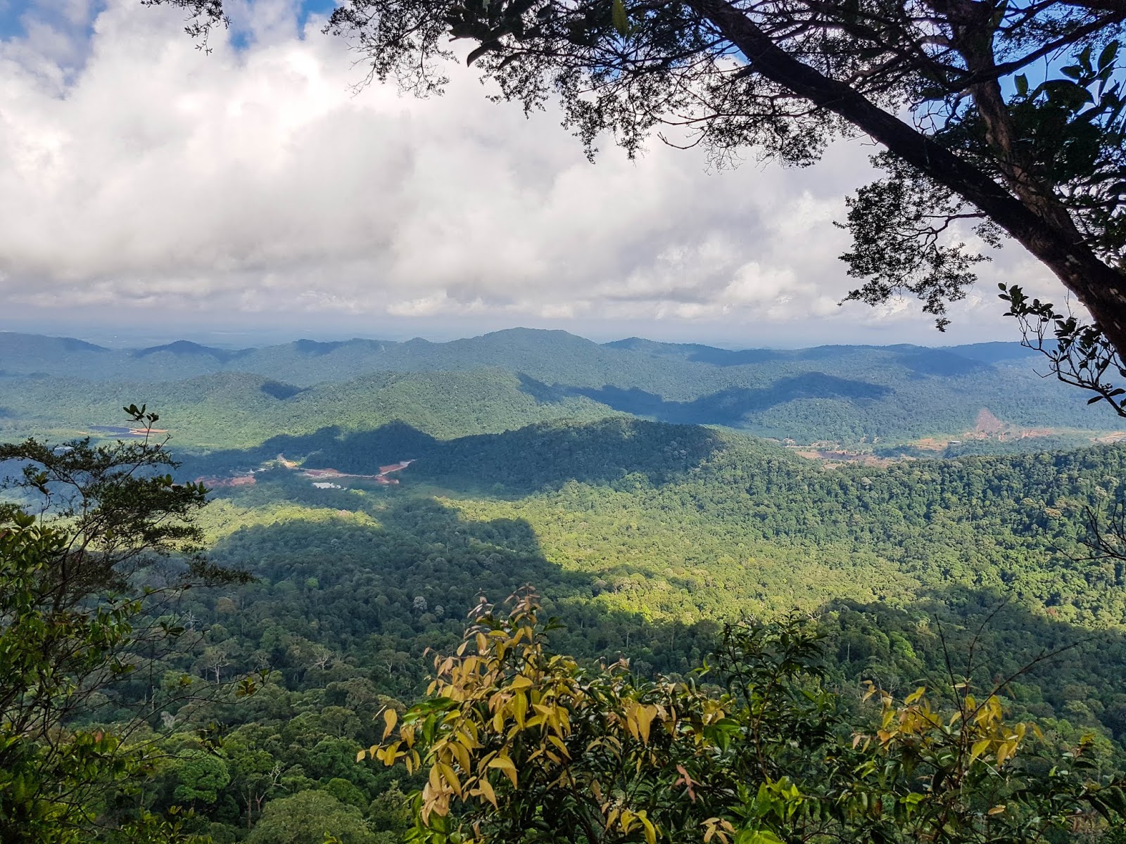
Summit
We reached the summit 5 minutes before 10am, but many local hikers were already there, chilling at the wooden bench. I was surprised to see the wooden furniture up at the summit, which are likely carried up by some pioneer hikers so that fellow hikers can chill, rest, and recharge before descending.
 |
| Is this a mamak stall? Look happening though *grin* |
 |
| View point with a bench |
 |
| The view of Sumalayang range |
As the table and bench is occupied, we settled on Vambly’s groundsheet and had our little picnic time. We had kuihs, fruits, coffee and tea while enjoying the chilly weather and nice scenery.
 |
| The peak is on the other side |
 |
| I looked slim here so must post |
 |
| When can I hike Sumalayang? |
Descent
Lunch at Restoran Sin Mei Lee
Though Fenny suggested Kiang Kee Bak Kut Teh for lunch, Vambly suggested Sin Mei Lee mutton pot and curry fish head instead, so off we went along with Restoran Sin Mei Lee. When you have a foodie, follow a foodie’s recommendation and you will never go wrong.
 |
| Curry fish head, fried homemade tofu, stir-fry baby kailan and braised mutton soup |
Indeed, the meal there is so delicious, I had to give two thumbs up. Highly recommended. Be sure to order what we did, and you will never go wrong.
Restoran Sin Mei Lee
Address: Jalan Tepi Sungai, Kampung Makam, 81900 Kota Tinggi, Johor, Malaysia
Operating hours: Daily, 12pm – 9.30pm
Epilogue
Though short, some part of the trail is quite steep, so it was a great workout for me after a long hiatus from hiking. Although steep at certain parts of the trek, it’s not that difficult, and I’d probably rank it as a “easy to moderately easy”, due to the short distance. You’ll see many hikers bringing their kids along for this hike, but most of them are aren’t beginners so to speak.
 |
| Short hike but pretty nice view. Worth it! |
Nonetheless, it’s easier than Gunung Pulai, and the view is also better, making this a great choice to sweat it out if you have a car to get here. I know I will be back again, hopefully soon!
---------------------------------------------------------------------------------------------------------------------------------------------------
Thank you for reading all the way till the end. Too much info and you just want a summarised itinerary but too lazy to scroll back up? Here’s a summary I’ve drafted up for you. Hope it helps you with your planning.
Itinerary:
**Disclaimer: Below is my timing according to my speed. So please take it with a grain of salt, as everyone have different pace. Have fun hiking this mountain. *wink*
Day Hike
Total distance hiked: approximately 9km return (one creek crossing)
0800: Gather at trail head
0815: Start hiking
0830: Reach log bridge – creek crossing
0900: Reach rest point
0940: Reach rock wall
0955: Reach peak (Panti Barat)
1130: Descent
1240: Reach trail head
---------------------------------------------------------------------------------------------------------------------------------------------------
-Thanks for reading-


Sounds good,going tomorrow so will let you all know how it is<
ReplyDeleteHi, can we hike the mountain without a guide?
ReplyDeleteHi, yes you can, but i don't recommend going alone or without someone who knows the way. Better be safe than sorry
DeleteHi can we hike without a guide?
ReplyDeleteHi, yes you can, but i don't recommend going alone or without someone who knows the way. Better be safe than sorry
Delete26/09/2020 see you there...
ReplyDeleteI will be going there next week... Who wanna join?
ReplyDeleteHi may I ask if we will need to apply permit before hiking this panti?
ReplyDeleteHi Siew Lee, most hikers hike this without a permit and no one is there to check (info is accurate as of the time of this blog post)
DeleteEskişehir
ReplyDeleteDenizli
Malatya
Diyarbakır
Kocaeli
DTG
goruntulu show
ReplyDeleteücretli
VENDH
10A54
ReplyDeleteTekirdağ Fayans Ustası
Tokat Lojistik
Karaman Parça Eşya Taşıma
Bitci Güvenilir mi
Muş Lojistik
Mersin Lojistik
Ardahan Lojistik
Kucoin Güvenilir mi
Bursa Lojistik
77332
ReplyDeleteKilis Şehirler Arası Nakliyat
Manisa Şehirler Arası Nakliyat
Kırıkkale Şehir İçi Nakliyat
Van Evden Eve Nakliyat
Karaman Parça Eşya Taşıma
Manisa Şehir İçi Nakliyat
Samsun Şehirler Arası Nakliyat
Kayseri Parça Eşya Taşıma
Bursa Şehirler Arası Nakliyat
6C316
ReplyDeletefat burner for sale
Karaman Evden Eve Nakliyat
Ardahan Evden Eve Nakliyat
buy anapolon oxymetholone
https://steroidsbuy.net/
Silivri Boya Ustası
Silivri Cam Balkon
Urfa Evden Eve Nakliyat
oxandrolone anavar for sale
43DD7
ReplyDeleteaksaray canlı görüntülü sohbet odaları
ordu kadınlarla sohbet et
antalya sesli görüntülü sohbet
istanbul rastgele sohbet
trabzon parasız görüntülü sohbet
goruntulu sohbet
canlı sohbet odası
karabük sesli sohbet siteler
antalya parasız görüntülü sohbet uygulamaları
50436
ReplyDeletecanlı sohbet
maraş yabancı görüntülü sohbet
urfa yabancı görüntülü sohbet uygulamaları
gümüşhane ücretsiz sohbet odaları
zonguldak canlı görüntülü sohbet
yozgat yabancı sohbet
adıyaman seslı sohbet sıtelerı
Niğde Telefonda Kadınlarla Sohbet
mersin rastgele görüntülü sohbet uygulamaları
شركة تسليك مجاري zUKQ6A1l60
ReplyDeleteشركة تنظيف بيوت بالدمام VLgOkqzips
ReplyDelete56D479C86F
ReplyDeletetakipci satin al guvenilir
2FBF6116FF
ReplyDeleteucuz takipçi
Brawl Stars Elmas Kodu
M3u Listesi
Binance Referans Kodu
Dragon City Elmas Kodu
Zula Hediye Kodu
Bitcoin En Güvenilir Nereden Alınır
Pubg Hassasiyet Kodu
101 Okey Vip Hediye Kodu
3E91765CD8
ReplyDeleteen ucuz tiktok takipçi
twitter beğeni satın al
mobil ödeme takipçi
telafili takipçi
düşmeyen takipçi
Hi Catherine
ReplyDeleteWe are a group of 10 adults planning to do this trip can you pls help to connect me on my email rakesh.chidurala@gmail.com if your the right person to organize the hike else pls redirect me to the right one
महाकालसंहिता कामकलाकाली खण्ड पटल १५ - कामकलाकाल्याः प्राणायुताक्षरी मन्त्रः
ReplyDeleteओं ऐं ह्रीं श्रीं ह्रीं क्लीं हूं छूीं स्त्रीं फ्रें क्रों क्षौं आं स्फों स्वाहा कामकलाकालि, ह्रीं क्रीं ह्रीं ह्रीं ह्रीं हूं हूं ह्रीं ह्रीं ह्रीं क्रीं क्रीं क्रीं ठः ठः दक्षिणकालिके, ऐं क्रीं ह्रीं हूं स्त्री फ्रे स्त्रीं ख भद्रकालि हूं हूं फट् फट् नमः स्वाहा भद्रकालि ओं ह्रीं ह्रीं हूं हूं भगवति श्मशानकालि नरकङ्कालमालाधारिणि ह्रीं क्रीं कुणपभोजिनि फ्रें फ्रें स्वाहा श्मशानकालि क्रीं हूं ह्रीं स्त्रीं श्रीं क्लीं फट् स्वाहा कालकालि, ओं फ्रें सिद्धिकरालि ह्रीं ह्रीं हूं स्त्रीं फ्रें नमः स्वाहा गुह्यकालि, ओं ओं हूं ह्रीं फ्रें छ्रीं स्त्रीं श्रीं क्रों नमो धनकाल्यै विकरालरूपिणि धनं देहि देहि दापय दापय क्षं क्षां क्षिं क्षीं क्षं क्षं क्षं क्षं क्ष्लं क्ष क्ष क्ष क्ष क्षः क्रों क्रोः आं ह्रीं ह्रीं हूं हूं नमो नमः फट् स्वाहा धनकालिके, ओं ऐं क्लीं ह्रीं हूं सिद्धिकाल्यै नमः सिद्धिकालि, ह्रीं चण्डाट्टहासनि जगद्ग्रसनकारिणि नरमुण्डमालिनि चण्डकालिके क्लीं श्रीं हूं फ्रें स्त्रीं छ्रीं फट् फट् स्वाहा चण्डकालिके नमः कमलवासिन्यै स्वाहालक्ष्मि ओं श्रीं ह्रीं श्रीं कमले कमलालये प्रसीद प्रसीद श्रीं ह्रीं श्री महालक्ष्म्यै नमः महालक्ष्मि, ह्रीं नमो भगवति माहेश्वरि अन्नपूर्णे स्वाहा अन्नपूर्णे, ओं ह्रीं हूं उत्तिष्ठपुरुषि किं स्वपिषि भयं मे समुपस्थितं यदि शक्यमशक्यं वा क्रोधदुर्गे भगवति शमय स्वाहा हूं ह्रीं ओं, वनदुर्गे ह्रीं स्फुर स्फुर प्रस्फुर प्रस्फुर घोरघोरतरतनुरूपे चट चट प्रचट प्रचट कह कह रम रम बन्ध बन्ध घातय घातय हूं फट् विजयाघोरे, ह्रीं पद्मावति स्वाहा पद्मावति, महिषमर्दिनि स्वाहा महिषमर्दिनि, ओं दुर्गे दुर्गे रक्षिणि स्वाहा जयदुर्गे, ओं ह्रीं दुं दुर्गायै स्वाहा, ऐं ह्रीं श्रीं ओं नमो भगवत मातङ्गेश्वरि सर्वस्त्रीपुरुषवशङ्करि सर्वदुष्टमृगवशङ्करि सर्वग्रहवशङ्करि सर्वसत्त्ववशङ्कर सर्वजनमनोहरि सर्वमुखरञ्जिनि सर्वराजवशङ्करि सर्वलोकममुं मे वशमानय स्वाहा, राजमातङ्ग उच्छिष्टमातङ्गिनि हूं ह्रीं ओं क्लीं स्वाहा उच्छिष्टमातङ्गि, उच्छिष्टचाण्डालिनि सुमुखि देवि महापिशाचिनि ह्रीं ठः ठः ठः उच्छिष्टचाण्डालिनि, ओं ह्रीं बगलामुखि सर्वदुष्टानां मुखं वाचं स्त म्भय जिह्वां कीलय कीलय बुद्धिं नाशय ह्रीं ओं स्वाहा बगले, ऐं श्रीं ह्रीं क्लीं धनलक्ष्मि ओं ह्रीं ऐं ह्रीं ओं सरस्वत्यै नमः सरस्वति, आ ह्रीं हूं भुवनेश्वरि, ओं ह्रीं श्रीं हूं क्लीं आं अश्वारूढायै फट् फट् स्वाहा अश्वारूढे, ओं ऐं ह्रीं नित्यक्लिन्ने मदद्रवे ऐं ह्रीं स्वाहा नित्यक्लिन्ने । स्त्रीं क्षमकलह्रहसयूं.... (बालाकूट)... (बगलाकूट )... ( त्वरिताकूट) जय भैरवि श्रीं ह्रीं ऐं ब्लूं ग्लौः अं आं इं राजदेवि राजलक्ष्मि ग्लं ग्लां ग्लिं ग्लीं ग्लुं ग्लूं ग्लं ग्लं ग्लू ग्लें ग्लैं ग्लों ग्लौं ग्ल: क्लीं श्रीं श्रीं ऐं ह्रीं क्लीं पौं राजराजेश्वरि ज्वल ज्वल शूलिनि दुष्टग्रहं ग्रस स्वाहा शूलिनि, ह्रीं महाचण्डयोगेश्वरि श्रीं श्रीं श्रीं फट् फट् फट् फट् फट् जय महाचण्ड- योगेश्वरि, श्रीं ह्रीं क्लीं प्लूं ऐं ह्रीं क्लीं पौं क्षीं क्लीं सिद्धिलक्ष्म्यै नमः क्लीं पौं ह्रीं ऐं राज्यसिद्धिलक्ष्मि ओं क्रः हूं आं क्रों स्त्रीं हूं क्षौं ह्रां फट्... ( त्वरिताकूट )... (नक्षत्र- कूट )... सकहलमक्षखवूं ... ( ग्रहकूट )... म्लकहक्षरस्त्री... (काम्यकूट)... यम्लवी... (पार्श्वकूट)... (कामकूट)... ग्लक्षकमहव्यऊं हहव्यकऊं मफ़लहलहखफूं म्लव्य्रवऊं.... (शङ्खकूट )... म्लक्षकसहहूं क्षम्लब्रसहस्हक्षक्लस्त्रीं रक्षलहमसहकब्रूं... (मत्स्यकूट ).... (त्रिशूलकूट)... झसखग्रमऊ हृक्ष्मली ह्रीं ह्रीं हूं क्लीं स्त्रीं ऐं क्रौं छ्री फ्रें क्रीं ग्लक्षक- महव्यऊ हूं अघोरे सिद्धिं मे देहि दापय स्वाहा अघोरे, ओं नमश्चा ameya jaywant narvekar