
Gunung Nuang via Pangsoon (Hulu Langat) – Popular Training Ground For Upcoming Big Hikes

Exactly 4 years ago (15 Oct 2016) on Facebook, I wrote:
“First Nuang experience, 20km hike... The most strenuous day hike I ever did. No wonder this place is training ground for G7 mountains... I should have come sooner!”
As Facebook reminded me of my first Nuang hike 4 years ago, I recalled that I have never blogged about this hike before. Back then I have just started my blog and was more interested in blogging about my oversea and local travels. Day hike was not in my interest. However, as time passed, I hiked more and more hills and mountains and ended up writing about every single hike regardless of the difficulty and duration. It’s a pity Nuang were left out despite being a very interesting hike and an important milestone in my hiking life.
So, even if I’m four years late in documenting this hike, I would like to share with you about this hike and what to expect (though the trail may have change slightly in 4 years time). Without further ado, let’s begin!
About Gunung Nuang
At 1493 metres high, Gunung Nuang is one of the highest mountain in Selangor. Though seemed like a baby in comparison to Mount Kinabalu (4095m), it is by no means any easier considering one is hiking it in a day. Generally, the hike is rated as difficulty as part of the trail is steep and the long duration requires high endurance. This makes Gunung Nuang an ideal training ground for those attempting multi-days hikes such as Tahan, Kinabalu, Rinjani and Nepal’s EBC or ABC trek.
Generally, it takes about 6 hours in average for a return trip from Janda Baik whereas those entering from Pangsoon, Hulu Langat will take approximately 8-10 hours for those who are generally fit. Experienced, super fit hikers could complete much earlier while beginners may take longer.
How To Get There
There are two entrance points to Gunung Nuang, one from Pangsoon (Hulu Langat) and the other from Janda Baik.
Trail heads:
Via Pangsoon, Hulu Langat (Selangor)
Coordinates: N3.217219, E101.883205
Address: Hutan Lipur Gunung Nuang, Kampung Pungsun, 43100 Hulu Langat, Selangor
Permit: RM5 (to apply two weeks in advance)
Parking: RM3
Toilet/Shower fee: RM1 (if I remember correctly)
Via Janda Baik (Pahang)
Coordinates: N3.303979, E101.887121
Address: Hutan Lipur Gunung Nuang, Kampung Pungsun, 43100 Hulu Langat, Selangor
Permit: RM10 + RM5
I’ve personally only hiked Nuang twice, and both via Hulu Langat (Pangsoon). It is said that the hike from Janda Baik is relatively easier but it’s a lot more convenient for KL and Selangor peeps to drive to Hulu Langat instead of Janda Baik, hence why I have only done it via Hulu Langat. Perhaps I should try Janda Baik someday?
How Apply Permit (via Hulu Langat)
When I hiked Gunung Nuang back in 2016 (first hike) and 2017 (my failed Trans Nuang Reverse hike), one can enter by just paying parking and entrance fee without a need for a permit. However, various accidents were reported around 2018-2019 and the mountain were closed for a period of time before re-opening sometime in late 2019. Ever since then, a permit is a must to hike Gunung Nuang, and one must apply for it at least two weeks in advance.
Address: Pejabat Daerah Hutan Daerah Selangor Tengah, Block B, Tingkat 1, Platinum Cheras, Jalan Zen 1, 43200, Cheras
Operating hours: Monday – Thursday (8.00am – 1.00pm, 2.00pm – 5.00pm), Friday (8.00am – 12.15pm, 2.45pm-5.00pm), Close on Saturday and Sunday
Phone number: +603-90814918
Email: phdseltgh@yahoo.com
Fee: RM5
From what is shared by various parties who had tried applying for the permit, it is a lot faster if you make a trip personally to the Forestry Department. However, if you can’t be there in person, you can apply by writing an email but do make sure to call and follow up in case they miss your email.
How Apply Permit (via Janda Baik)
Although Janda Baik is located in Pahang, Nuang Peak actually sits on Selangor, therefore officially, you would need two permit, one from Jabatan Hutan Pahang and another from Pejabat Daerah Hutan Daerah Selangor Tengah (as shared above).
Address: Pejabat Hutan Daerah Bentong, Kampung Baru Bentong, 28700 Bentong, Pahang
Operating hours: unknown
Phone number: +609-2221039
Website: http://apps.forestry.pahang.gov.my/ekorimba/main/index.php
Fee: RM10
Information online states that you can apply online via the website above but payment can’t be made online. Instead, the fees shall be made in money order or bank draft under the name Pengarah Perhutanan Negeri Pahang. For more detail information, I would suggest giving them a call to better clarity.
The Hike Via Pangsoon Hulu Langat
5km “never-ending” old logging road
The first section of the hike is what most hikers called the “never-ending road” which is actually a 5km undulating old logging road. Though wide enough for 4WD to pass through, it is not accessible. However, occasionally, you will come across locals who ride pass with their motorbikes. I heard that in the late evening, they would offer to fetch hikers out for a fee.
 |
| With Eunice and WN during my first Nuang hike |
 |
| I was very slim back then |
 |
| Feeling fresh when we just started our hike on the never ending road |
 |
| One of the 6 huts |
Thick bamboo forest lines each side of the track and the loud insect, bird and monkey calls would accompany you throughout your one-hour hike along this road. The road is generally clear but it slopes upwards and downwards and could get a little tiring, especially on your way out later on since you might have exhausted yourself. There are resting huts along the path and I counted about 6 of them. I remember the huts look a little eerie so I never stop and rest there at all.
Stream crossing to Kem Lolo
The last hut is next to a small stream which we would need to cross, after which you would then need to follow a narrow path that leads to an old water pipeline before reaching a waterfall and a water sluice gate where you need to cross the second stream, then the third and fourth stream. If I remember correctly, there is a fifth and final stream to cross in order to reach Kem Lolo. There is a huge log bridge which you can choose to cross over if you wish to stay dry.
 |
| One of the stream crossing |
 |
| Crossing the bridge |
Some people would choose to camp overnight at Kem Lolo before hitting the summit the next day, since it is the only campsite here with proper water source. However, I don’t find it ideal as it is still a long way to the peak. I would prefer doing Nuang as a day hike instead of wasting time camping here.
Kem Pacat
The trail towards Kem Pacat is mostly deeply rutted clay which will be rather slippery and tough if it rains heavily. Thankfully, for both my hike in 2016 and 2017, I was blessed with sunny weather. The journey to Kem Pacat is quit an uphill battle as some points were pretty steep that we need to rely on ropes to haul ourselves up. When you finally reach a big clearing, you will know you have reached Kem Pacat.
It’s a good place to get some rest before continuing your way to the peak, and some people will have their meal here. If you are pressed for time, I suggest cutting your break and have your meal on the peak instead.
 |
| The twisted tree |
 |
| Taking a photo here is a must |
 |
| Woohoo! |
There’s also a big twisted tree on this campsite which makes for a good photo spot. If you can wait, I would suggest keeping this for when you descend from the peak later.
Kem Pengasih
The toughest part of the hike is none other than the stretch from Kem Pacat to Kem Pengasih. The trail is steeper than earlier and at certain points we would need to be grapping on the roots and ropes to haul ourselves up. Hiking sticks would be redundant for this part of the trail.
 |
| The trail can get pretty muddy |
Kem Pengasih is a false peak nestled among some mossy forest. It is wet and muddy and because the wind had picked up, it is also a little chilly, though nowhere near the climate in Fraser Hills or Cameron Highlands.
Nuang Peak
From Kem Pengasih, the path towards the peak is rather easy. The trail is gently flat followed by a series of gentle downhills before your final push to the peak.
 |
| View from the peak |
 |
| I looked so haggard |
 |
| Gavin, myself, Wills and Kin Mun |
 |
| Another photo of the view before descending |
As you emerged, you will see a triangulation station which indicates that you have reached the peak. During my time, the signboards were hanged on a tree, but from the photo circulated on the internet in recent years, there is now a big wooden sign right in front of the triangulation station. If you walk further to the edge of the peak, you can take a peek through the gap in the bushes where you would get the view of surrounding greeneries and a dam.
 |
| 4 years ago there weren't any wooden sign in front of the triagulation station, so people hanged signs on this tree |
 |
| Photo at the peak is a must |
 |
| This was taken 3 years ago |
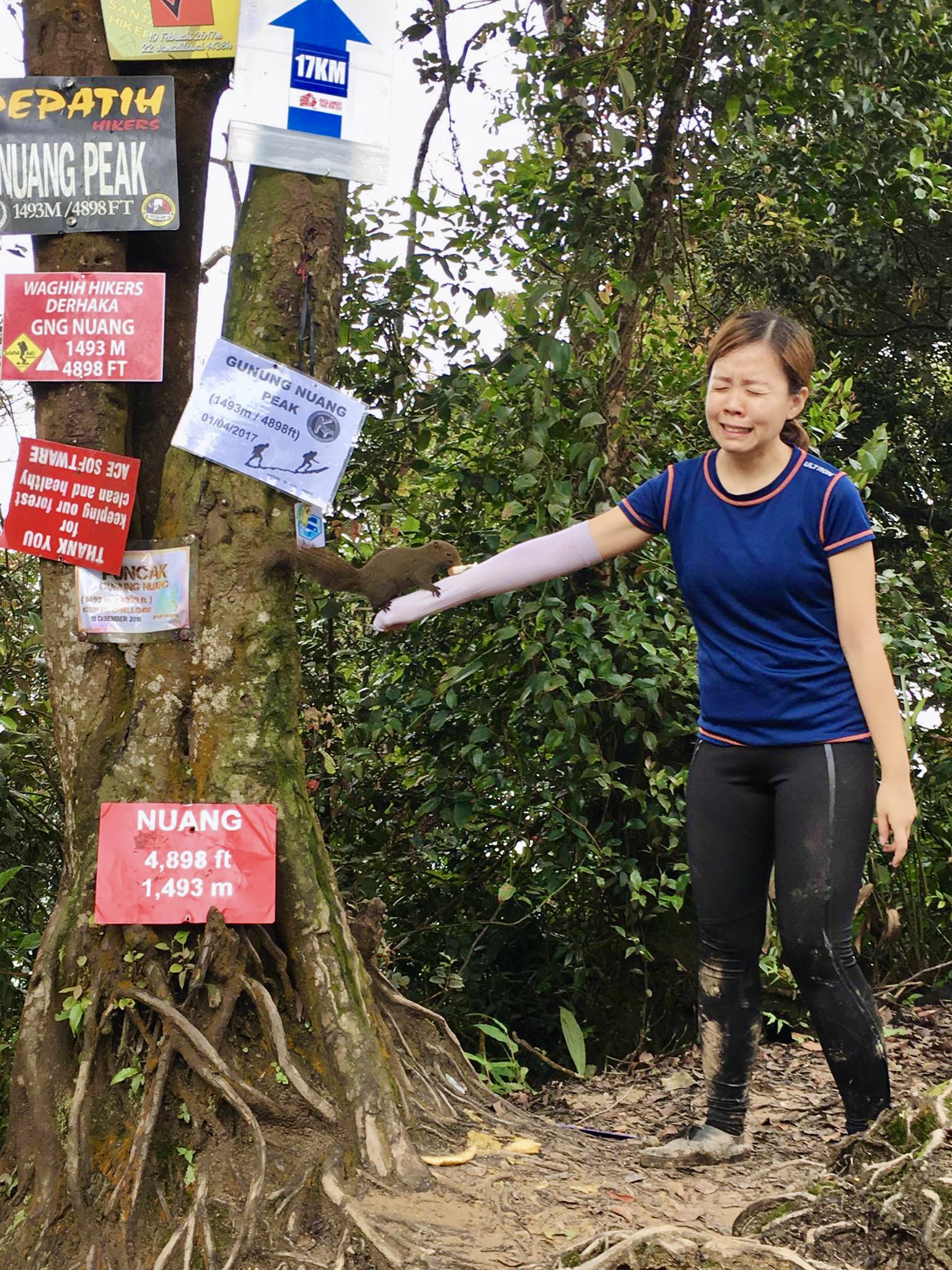
There are squirrels on the peak which aren’t afraid of us human beings, and on my second visit, I tried to feed them to have them crawl to my arms. They are adorable but the photos below proved how frightened I was when they went on my arms. I’m a scaredy cat, I know!
 |
| Why are you so adorable? |
 |
| Squirrel squirrel on the tree |
 |
| Help~! |
 |
| I want my mommy! LOL |
Descent
Most people take shorter time to descend but it really depends on individual. As the trail is steep from Kem Pengasih to Kem Pacat and from Kem Pacat to Kem Lolo, do proceed with caution as the ground could get slippery and you may risk falling and injured. This is where the ropes come in handy.
 |
| Group photo with everyone when we descent 4 years ago |
Just as you though you have passed all the steep part of the trail, the last 5km “never-ending road” could be a mood-killer. For both times I hiked Nuang, I were swearing throughout the entire 5km. Thank goodness at the end of the hike, there’s a vendor selling chilled soft drinks and toilet facilities for me to freshen up.
Final Words
I can’t believe it’s been four years since my first hike to Nuang, and three years since my last hike. I always tell my friends that I prefer to explore new mountains instead of revisiting those I’ve hiked, but with Nuang, even having hiked twice, each time feels different and I don’t mind returning again for the third time or more. The only thing I hate? Definitely the 5km never ending road, especially during descent!
Now that I’m based in Malaysia already, let’s hope I get to find time to revisit Nuang. I bet things had been different from 3-4 years ago, and who knows I may go crazy and re-attempt Trans Nuang Reverse again. Oops!
---------------------------------------------------------------------------------------------------------------------------------------------------
Thank you for reading all the way till the end. Too much info and you just want a summarised itinerary but too lazy to scroll back up? Here’s a summary I’ve drafted up for you. Hope it helps you with your planning.
**Disclaimer: Below is my timing according to my speed. So please take it with a grain of salt, as everyone have different pace. Have fun hiking this mountain. *wink*
Day Hike
Total distance hiked: approximately 20km return (stream crossing at Kem Lolo)
First Hike Oct 2016 (tip top condition)
08:00 Start hiking from trail head
09:00 Reach Kem Lolo
10:00 Reach Kem Pacat (30 min break)
10:30 Leave Kem Pacat
11:30 Reach Kem Pengasih
12:00 Reach peak (30 min break)
12:30 Leave peak
13:30 Reach Kem Pacat (1 hour lunch break)
14:30 Leave Kem Pacat
16:00 Reach trail head
Second Hike April 2017 (in bad shape)
05:30 Start hiking from trail head
07:00 Reach Kem Lolo
08:30 Reach Kem Pacat (30 min break)
09:00 Leave Kem Pacat
10:30 Reach Kem Pengasih (30 min break)
11.00 Leave Kem Pengasih
12:00 Reach peak (1 hour break)
13:00 Leave peak
14:00 Reach Kem Pacat
14:30 Leave Kem Pacat
17:30 Reach trail head
Note: Looking at the above timing on my two hikes, it is clear that speed varies according to individual and their condition of the day. I was at tip-top condition during my first hike and I was down with a bad flu during my second hike. Experience and fitness level would also play a part. I had just done my Gunung Tahan hike prior to my first Nuang hike and was really fit back then.
Nonetheless, be prepared to spend about an average 10-12 hours if you are hiking for the first time. Try to start as early as possible so that you can complete the hike before nightfall, and bring all the necessities such as sufficient drinking water, headlights, first aid kit, sufficient food and rain jacket. I would also recommend setting a cut off time to make a U-turn (say, around 2pm?) so that you don’t get stranded in the mountain after nightfall and risks getting lost or injured. Planning your hike on weekend is also a wise choice as there would be more crowd and higher chance of getting any necessary help if ever needed.
---------------------------------------------------------------------------------------------------------------------------------------------------
Alternative hiking route:
***Disclaimer: The following tips are formed based on my personal opinion. As I’m not a mountain guide nor professional hiker, please exercise your own judgment before following.
❶Pangsoon trailhead > Nuang Peak > Pangsoon trailhead
This was what I did during my first Nuang hike (and is what is documented in this post), and is a common route for most people residing in KL or Selangor.
❷Janda Baik trailhead > Nuang Peak > Janda Bail trailhead
This is the second common route especially for those residing nearer to Janda Baik side. It’s relatively shorter and easier.
❸Trans Nuang: Pangsoon trailhead > Nuang Peak > Janda Baik trailhead / Janda Baik trailhead > Nuang Peak > Pangsoon trailhead
To take one this route, transportation needs to be sorted out as you would enter from one trailhead and exit from another. It is doable by parking a car at the exit and drive another car to your starting trail head, but the distance between two trail head is about 2-hours drive. Another solution is to break your hiking group into two while each starting from different trailheads and exchange your car keys when you meet in the mountain. Anyway, proper planning is required.
❹Trans Nuang Reverse: Pangsoon trailhead > Nuang Peak > Janda Baik trailhead > return / Janda Baik trailhead > Nuang Peak > Pangsoon trailhead > return
I attempted this back in April 2017 to train for my Chamah hike but did not complete as I was down with flu. Trans mean doing the hike from one end to another (Hulu Langat-peak-Janda Baik or Janda Baik-peak-Hulu Langat). Reverse here means, going back to where you come from. An estimated of 16-18hrs is needed for an average fit hiker, and as you can tell from my previous achievement, it is something I am capable of doing. Unfortunately, I couldn’t breathe properly on the day of my hike and ended up only going to Nuang Peak and return. It was my worse achievement to date as I spent 12 hours (instead of 6hours+ during my first Nuang hike in Oct 2016). I would love to re-attempt this hike someday.
---------------------------------------------------------------------------------------------------------------------------------------------------
-Thanks for reading-


Great sharing, Thanks !!
ReplyDeleteayvalık transfer
ReplyDeleteçeşme transfer
urla transfer
akbük transfer
davutlar transfer
8WM