
Trans Bukit Payung: Legend of the White Robe Men

Before joining Max Mountain Club (MMC), I’ve never heard of these hills before, so when a plan to hike Gunung Ledang got cancelled due to the ridiculous price hike, I did not hesitate to vote for this when a poll was created to decide a substitute hiking destination (Actually, I voted for all options! *sweatgrinning*)
A little research about Bukit Payung while writing this post led me to the story of 1980 Batu Pahat Incident. More about that in "Bonus Read" section, but now... let's talk about my hike last month.
How To Get There
There are basically two trailheads, though only one is the official one:
Official Trail head | Kampung Kangkar Merlimau trailhead
The official trail head is only about 45 minutes away to Bukit Payung. There is a huge car park (RM 5 per car) in front of the trail head, and there is also shower facilities for hikers. This is ideal for those who only plan to cover only Bukit Payung instead of hiking all five peaks, or anyone who doesn’t have a 4wd and have the time and energy to do a trans reverse (hiking 5 peaks back and forth).
 |
| Registration/payment booth at the carpark |
 |
| Parking fee |
 |
| We parked our cars here and waited for Kenny to drop us at the second trailhead with his 4wd |
 |
| Part of us |
Second Trail Head | Oil Palm Plantation
If you however, conveniently have a 4wd with you, you may also choose to start your hike from an oil plan plantation which is only about 5-minute drive away from the official trail head, like what we did. Just be sure to park other cars at the other end of the trail (car park of Kampung Kangkar Merlimau trailhead). Unfortunately, I couldn’t find the map to this location, so do feel free to drop a comment down below if you have the said information to be shared.
 |
| Second trailhead |
Bukit Botak (Bald Hill)
The key to doing a Trans Bukit Payung is to start as early as possible. This is due to the rocky terrain, hence most section of the trail is exposed to the sun, especially at mid-day. It is also recommended to wear long sleeve top (or arm sleeves) and cap or bring along an umbrella.
 |
| Kenny made rounds dropping us to the second trailhead with his 4wd |
With Kenny dropping us at the oil palm plantation, we started our hike at 7.50am (we ended up being a little later than planned). The first section of the trail leading up from the plantation took me by surprise as it was unexpectedly quite steep.
Luckily it wasn’t long until it gradually turned gentle. In half an hour time, we reached what seemed like a huge campsite.
 |
| Ready? Let's begin |
 |
| Make sure you apply ample of sunblock or bring an umbrella, it's pretty exposed |
 |
| If you are slim enough you can get through the gap, otherwise, you can always climb over it (left) |
Luckily it wasn’t long until it gradually turned gentle. In half an hour time, we reached what seemed like a huge campsite.
 |
| Campsite? |
 |
| Resting hut #1 |
 |
| Resting hut #2 |
 |
| Left for Bukit Botak, Right for Bukit Berdiri |
From the sign, Bukit Botak is just a few hundred meters away.
 |
| 180 degree view from Bukit Botak |
 |
| Stunning, isn't it? |
 |
| Fat makes my face round. Damn! |
Bukit Berdiri (Standing Hill)
After taking turns at photos, we turned back and continued hiking towards Bukit Berdiri. Just like before, the trail here is wide, clear and well-marked, so it was quite a leisure hike and suitable for beginners. The terrain is dry and therefore no leeches are spotted throughout our entire hike. This, I like! *grin*
 |
| Wide like highway |
 |
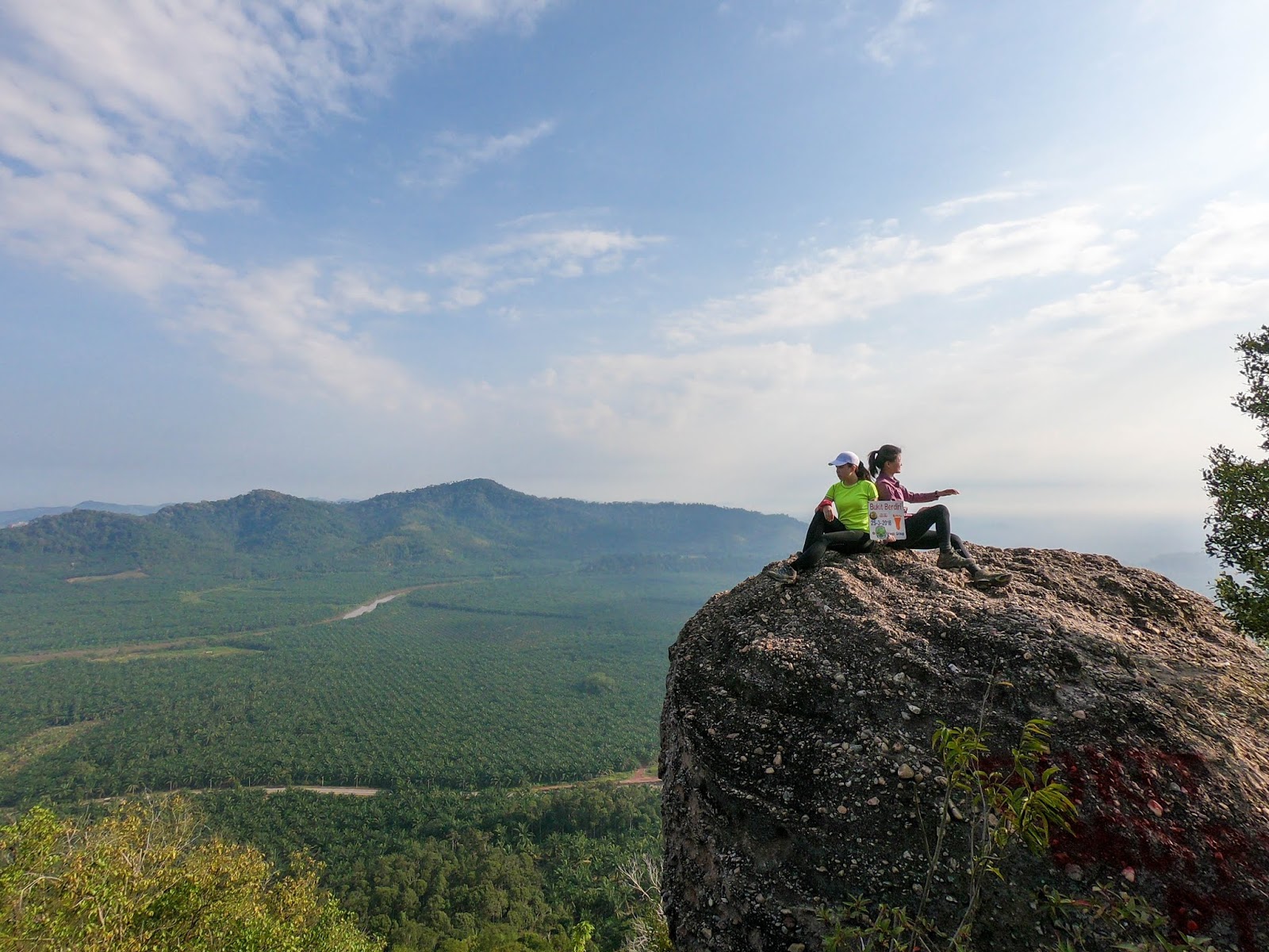
| Reached Bukit Berdiri |
 |
| Most beautiful photo spot |
In half an hour time, we reached Bukit Berdiri, which in my opinion is the most insta-worthy viewpoint here, which was why we spent about half an hour here trying to get the perfect shot.
 |
| #1 |
 |
| #2 |
 |
| #3 |
 |
| #4 |
 |
| #5 |
 |
| #6 |
 |
| #7 |
 |
| #8 |
From Bukit Berdiri, the trail leading to Bukit Payung goes downhill before going uphill again. This section of the trail is mostly exposed as we descent through low bushes. Thankfully, I got myself a cap and brought my umbrella which I put to good use. No more sunburnt skin, hooray!
Bukit Alam (Realm Hill) and Bukit Bungkuit (can't translate this, anyone?)
It’s worth noting that there are actually two more peaks along the way from Bukit Berdiri to Bukit Payung, known as Bukit Alam and Bukit Bungkuit but somehow, we overshot. After all, according to Kenny, they are the two peaks which do not have signs, unlike the rest. In fact, many locals only recognise three peaks to this hiking trail.
Probably by the time I return in the future, there will be signed on the other two peaks? We shall see.
Butik Payung (Umbrella Hill)
 |
| A trail diverged from the main road where we need to climb up a boulder next |
 |
| Ready to climb? |
The last section to Bukit Payung includes some scrambling, but nothing too difficult. It does remind me slightly of Tabur Far East and Tabur Extreme, the easier sister hills of Tabur East and Tabur West – moderately steep but short.
 |
| There is another path leading to a waterfall but we never head there |
 |
| Last part |
 |
| After this, we reach Bukit Payung |
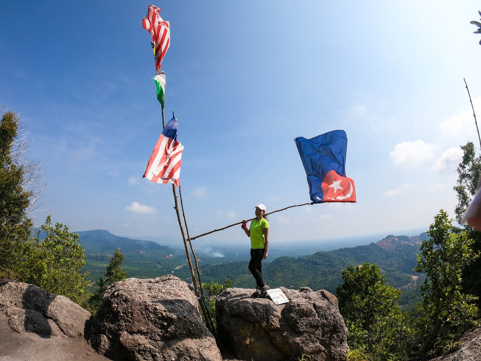
There, at the peak of Bukit Payung, lies a boulder, just like Bukit Botak and Bukit Berdiri, but what stood out was the National Flag and Johor State Flag standing proudly in between the two rocks.
Congratulations, you’ve reached the top of the hill, and it’s time for another round of photos.
 |
| Peak of Bukit Payung |
Congratulations, you’ve reached the top of the hill, and it’s time for another round of photos.
 |
| Fenny, me and Jesy |
 |
| Close up |
 |
| Solo photo is a must |
 |
| Best shot at Bukit Botak |
Lunch at Swee Kee Soup Restaurant
After the photo session and a short break, we started descending towards the carpark. It was a steep descent but again, nothing too taxing. In half an hour time, we finally reached our cars.
We ended our hike with lunch at Swee Kee Soup Restaurant, a popular soup place in Batu Pahat, before driving back to Johor Bahru and Singapore.
 |
| Time to descend |
 |
| Reach the foot of mountain (trailhead #1) |
 |
| Huh... Also need to pass through oil palm plantation to get the carpark |
 |
| Sprinting to the car! |
We ended our hike with lunch at Swee Kee Soup Restaurant, a popular soup place in Batu Pahat, before driving back to Johor Bahru and Singapore.
 |
| Their fish head curry is a must-try |
They only have 6 type of tonic soups option here, which are pork rib, chicken, black chicken, frog leg, turtle and duck. The main highlight for me however is definitely their curry fish head.
(Main Shop) Swee Kee Soup Restaurant
Address: 70, Jalan Abu Bakar, Kampung Pegawai, 83000 Batu Pahat, Johor, Malaysia
Opening Hours: 12:00pm to 8:00pm
Address: 70, Jalan Abu Bakar, Kampung Pegawai, 83000 Batu Pahat, Johor, Malaysia
Opening Hours: 12:00pm to 8:00pm
(Branch) Swee Kee Tonic Soup Restaurant
Address: No., 3, Jalan Setia Jaya 2, Taman Setia Jaya, 83000 Batu Pahat, Johor, Malaysia
Opening Hours: 12:00pm to 8:00pm
Epilogue
Although I have in the past been visiting Batu Pahat pretty often during my time in Ernst & Young Melaka, back then I never had the chance to climb any mountains or hills in Batu Pahat. I was glad that I was able to join MMC for this hike. It’s an easy leisure hike with rewarding view, which is perfect for the short weekend day hike.


The terrain is pretty similar to KL’s Tabur Hill which also provides a 180-degree panoramic view of its surrounding scenery. In fact, they both have rocky terrain, though the latter is more dangerous and requires more scrambling.


Overall, this is a pretty satisfying hike. Will I return? Definitely! Maybe I’ll wear a white shirt the next time I return. Till then…!
Also... a video by Vambly for this hike:
Now... for the bonus read I promised:
*Bonus Read*
1980 Attack of Batu Pahat Police Station
On October 16, 1980, white-robed men suspected to be members of a religious cult, attacked the Batu Pahat police station. They were followers of what was later deemed a deviant cult led by Ahmad Nasir Ismail who declared himself as Imam Mahdi, the prophesied redeemer of Islam who will rule before the Day of Judgment and will rid the world of evil.
The members of this cult were dubed the white-robed men as they dressed in white robe. According to the villagers of Kampung Mohd Noor, Batu Lima, Parit, they are often seen gathering in Bukit Payung, which is one of their hangout. They pratised religious rited and silat, which led them to believe that they were invincible. It is believed that they had attacked the police station as their first step to conquer the district before advancing to conquer the whole country.
The attack began around 9.30 that morning, when 15 of the cult members attacked from the front and back of the police station and slashed anyone found there. 25 people were injured in the attack, including policemen, a pregnant lady, six civil servants, a gangster and two civilian who were lodging a report. The attack ended with the death of six if the attackers, including the leader, Ahmad Nasir Ismail.
A fraction of the members also attacked the District Cadi Office and Syariah Court, in search of the judge who once claimed that their cult is heresy. The group then went hiding in a house in Parit Jorak Senawi, about 10km away from the attack, after fail to locate the said judge. The police later raided the house, but the members refused to surrender, leading to the death of two more members and injuries to the rest. The police found prayers, white flag with syahadah words and Jawi writings in green and white.
Following the attack, the government had ordered all police station in the country to set up a control station for surveillance purpose.
---------------------------------------------------------------------------------------------------------------------------------------------------
Thank you for reading all the way till the end. Too much info and you just want a summarised itinerary but too lazy to scroll back up? Here’s a summary I’ve drafted up for you. Hope it helps you with your planning.
Itinerary:
**Disclaimer: Below is my timing according to my speed. So please take it with a grain of salt, as everyone have different pace. Have fun hiking this mountain. *wink*
Day Hike
Total distance hiked: approximately 10km (no river crossing)
0720: Gather at Kampung Kangkar Merlimau trailhead (carpark)
0730: Drive to trailhead
0750: Start hiking
0820: Reach Bukit Botak
0840: Continue hiking
0905: Reach Bukit Berdiri
0930: Continue hiking
1030: Reach Bukit Payung
1055: Continue hiking
1130: Reach carpark
---------------------------------------------------------------------------------------------------------------------------------------------------
-Thanks for reading-


0 comments:
Post a Comment