
3D2N KorGa (Korbu-Gayong) : 2-In-1 G7, A Journey Not To Be Taken Lightly

KorGa (also known as Korbu and Gayong) are the two G7 of Peninsular Malaysia (G7 = 7 highest summit of Peninsular Malaysia, above 7000 feet).
(G2) Gunung Korbu 2183m / 7162ft
(G4) Gunung Gayong 2173m / 7129ft
I first heard about G7 after my Mount Tahan hike in 2016, thanks to fellow Tahan hikers who keep brainwashing me with the idea of completing G7. G7 is a bucket list for most hikers and as my passion on hiking grows, Korbu and Gayong have been among the two mountains I've always wanted to tick off my list.
But as we all learned, not everything goes as planned. For KorGa, it's three failed attempts to even start the hike.
 |
| Let's hike! |
My first chance to do KorGa came in Apr 2017, just a couple of months following my Mount Tahan hike, but having just changed a new job I gave it a miss, in order not to ruin my impression by taking leave during probation. With no luck to join the 3D2N camping trip, I was tempted to do a dayhike when a fellow hardcore hiker strongly persuaded me to join him for KorGa dayhike in Feb instead. Unfortunately, permit was applied way too late and we missed the hike. One year later, Uncle Mak decided to help accomplish this long overdue dream of my by organising a 3D2N camping trip only to cancel it last minute due to unforeseen personal reason.
Feeling guilty for standing me up, Uncle Mak planned another round this year and we had the date fixed during the Deepavali long weekend, perfect for a 3D2N camping trip.
How To Get There
Unless you are doing a Trans Titiwangsa, being V1, V2 or V3, the only other entrance point to Korbu and Gayong is via the Ulu Kinta Forest Reserve. It’s one of the most troublesome to arrange as you needed to apply for a permit probably up to a month in advance as it takes a long time for it to be processed. The cost of the permit is RM15 per person and can be applied and paid online from the Forestry Department of Malaysia website. On the day of the hike, drive up to Ulu Kinta Dam and show the permit in order to get in. The Dam gate opens at 6am and closes at 7pm.
Ulu Kinta Forest Reserve Entrance / Sultan Azlan Shah Dam a.k.a. Ulu Kinta Dam (N4.668629, E101.198266)
Before you make your way into the Dam, however, you are required to register yourself at the forestry office which is located just a stone’s throw away. There, you need to declare all the items you are bringing with you, have it inspected by the officers and fill up a declaration form.
Pejabat Hutan Lipur Ulu Kinta (N4.669633, E101.198376)
After declaring your belongings, you can proceed to the gate and drive to the trail head. You can park your car at the roadside, right in front of the trail head. There’s no toilet facilities here but hikers normally wash up at the river next to the trail head, so keep a set of clean clothing in your car.
 |
| Trail head |
Trail head parking (N4.649545, E101.240978)
Day 1: Short leisurely hike to Kem Seroja
For hikers doing a 3D2N, they normally camp either at Kem Seroja or Kem Kijang, both with water source. Camping at Kem Kijang shortens the hike on second day as you cut down at least 2-3 hours of total distance, however it’s known for sand-flies. Camping at Kem Seroja on the other hand means extra 2-3 hours of hiking on second day but you get a relaxing first and third day, especially if you are not too comfortable walking up steep trail with heavy load. Besides that, Kem Seroja is also a lot bigger, fits more people and doesn’t have sand-flies.
After much consideration, we decided to camp at Kem Seroja.
0945 Korga trail head
We started our hike at 9.45am from the trail head and the first part of the hike was rather flat and easy. There are plenty of small streams and rivers to cross, so wear a pair of shoes with a good grip. I went for Kampung Adidas while keeping my Merrell boots for the next day.
 |
| River crossing |
Some part of the trail especially at those sections involving river crossing can be a bit confusing, so it’s really important to join a leader who knows the way and download an offline map in case of getting lost.
1150 Reach Kem Balak
After two hours, you will reach Kem Balak, a small waterfall with water level reaching probably my chin. A big tree trunk stand vertically in the middle of the pond. Here, we took a short break, before continuing our journey to Kem Seroja.
 |
| Kem Balak waterfall |
 |
| Too afraid to go in there as it's up to my chest (or perhaps my chin) |
 |
| Let's just stand next to it for photo will do |
1210 Leave Kem Balak
The stretch from Kem Balak towards Kem Seroja is where it gets interesting. The trail became steeper and steeper with each passing steps, and with a heavy load on our back, it felt longer than an hour.
1315 Reach Kem Seroja
Our first day hike came to an end by lunch time, and each of us looked for a suitable spot to set up our tent. After pitching up the tent, we proceeded to wash up before settling down for lunch. We spent the entire afternoon drinking coffee and tea and I even had time to take an afternoon nap before dinner.
 |
| Kem Seroja |
 |
| Resting hut built by the rangers |
 |
| They left some ration at the hut so that any stranded hikers would have something to eat and not starve themselves |
 |
| The river where we washed up |
1700 Dinner and rest
We had early dinner (Chinese cured sausage rice) that night and went to bed early, making sure to wake up early the next day for a long hike.
 |
| Dinner time |
 |
| Chinese cured sausage rice for dinner |
Day 2 (Part 1): Up up and up to Gunung Korbu, the highest mountain on Titiwangsa Range
The second day is the toughest as one would need to hike for 12 to 16 hours from Kem Seroja to Gunung Korbu and then Gunung Gayong before returning to Kem Seroja. Therefore, it’s best to time your departure time in order to avoid hiking late in the night. The journey can be shorten by about 3 hours if you choose to base at Kem Kijang instead.
0535 Start ascent
 |
| Bacon pasta for breakfast, which we also packed for lunch |
We woke up as early as 4.30am for breakfast as we wanted to start our hike earlier. With our bags filled with lunch, snacks and enough drinking water, we started our hike at 5.30 with headlights to shine the way. The trail towards Kem Kijang began flat and easy, however we later had to climb over fallen trees and to cross over rivers in the dark. The trail gets rather confusing at certain parts, but since Uncle Mak and Zhan Yi had been there several times, they had no problem recognising the way.
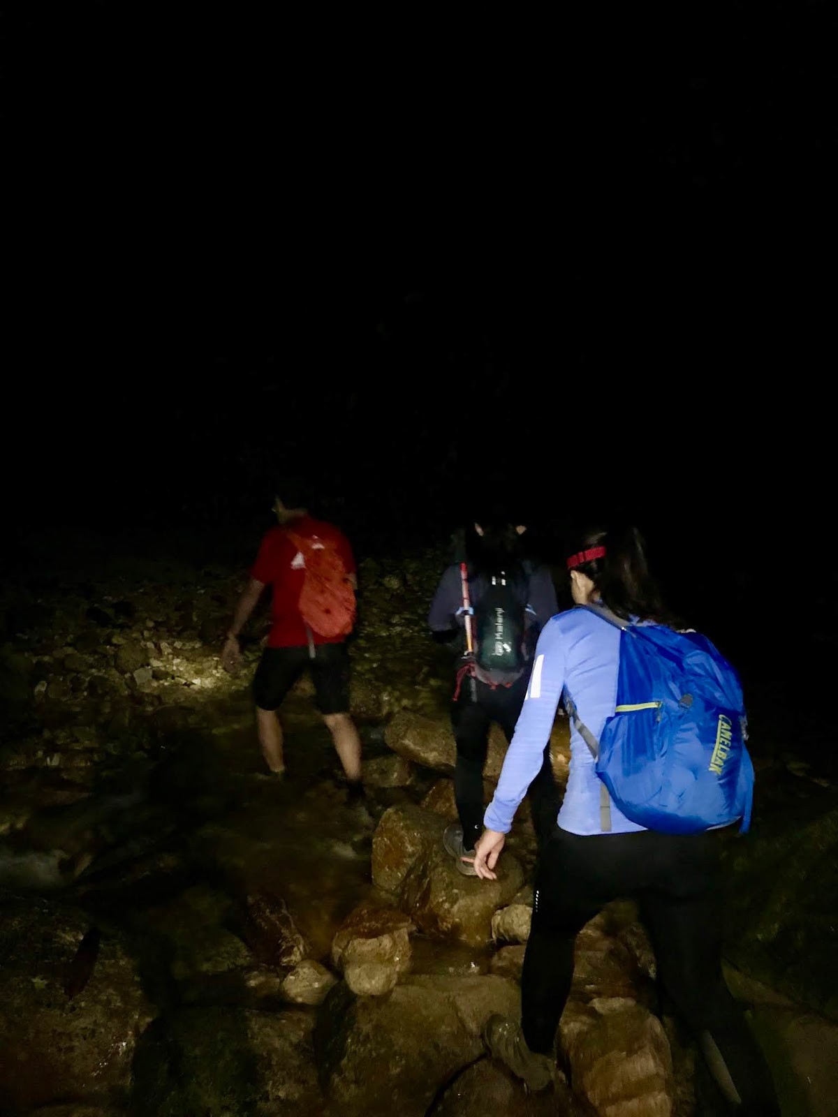 |
| Hiking in the dark |
0700 Reach Kem Kijang
We estimated an hour from Kem Seroja to Kem Kijang but unfortunately, it took us half an hour more for various reason – hiking in the dark and our body yet to warm up, well, as least for me. The sun was out by the time we crossed the river at Kem Kijang, but it was only the beginning – the trail only gets steeper and steeper from that point onwards, and soon the rest of the team were nowhere to be seen.
 |
| I can't imagine this in rainy days |
0800 Reach Last Water Point
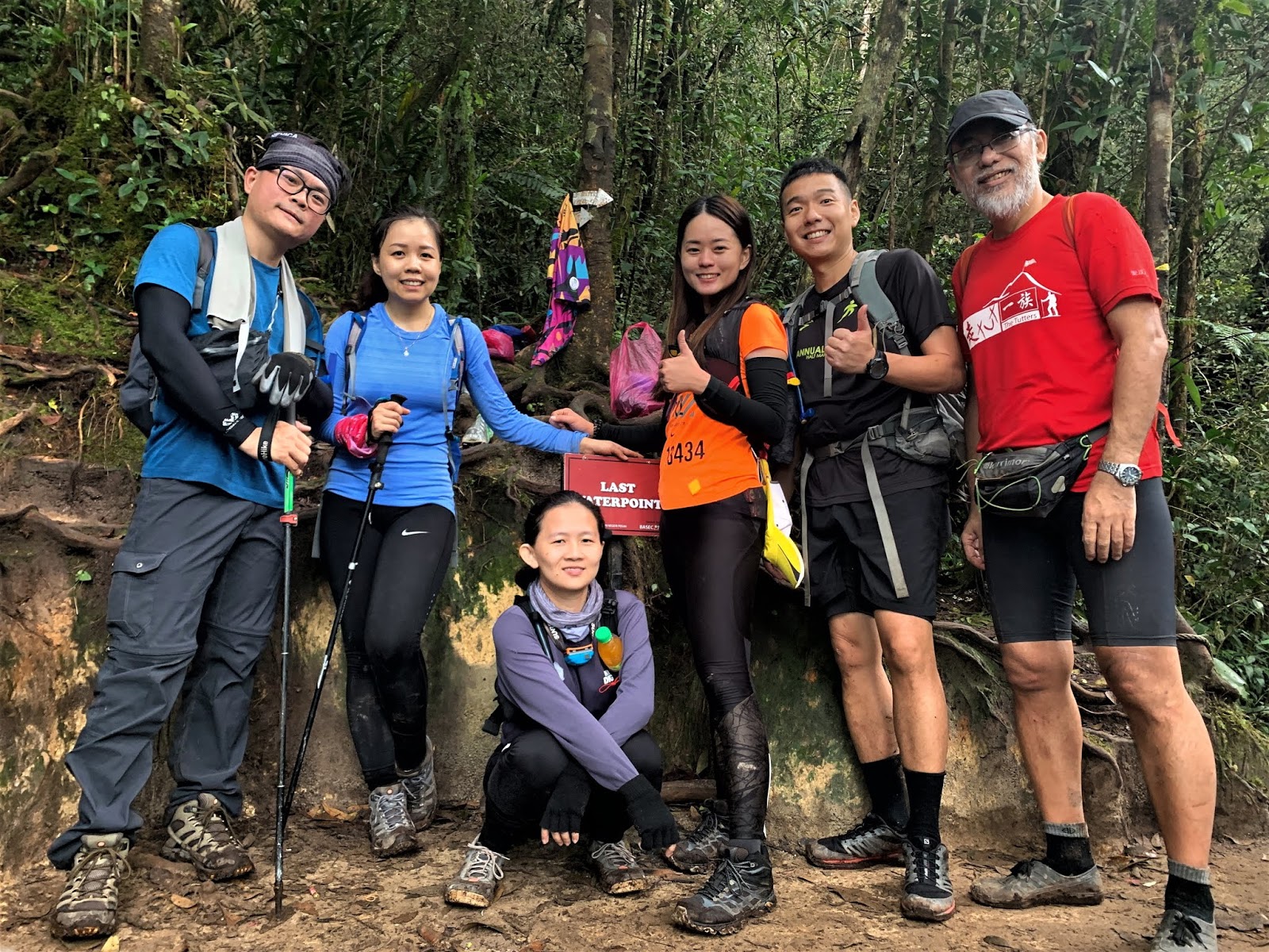 |
| Last Water Point |
Thankfully, it only took us an hour to reach the last water point. The place is named so as there is no more water source from this point onwards to Gunung Korbu and Gunung Gayong. My water supply was last enough to last me the entire day, but if you drink a lot, be sure to fill your bladder up. The trail gets steeper after last water point and you will begin to see ladders after ladders being installed along the way for assistance.
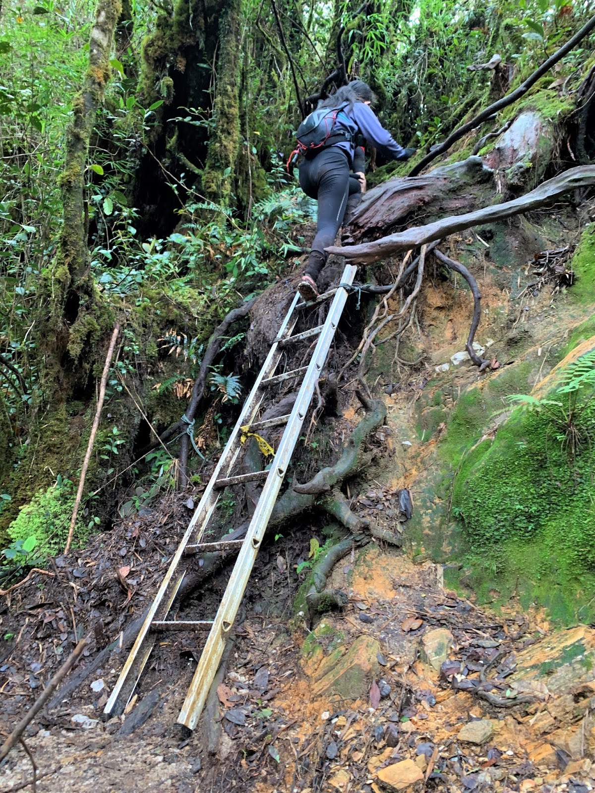 |
| Ladders, ladders and ladders all the way |
It was pretty intimidating at some point and the thought of the recent accident where a hiker fell to his death kept haunting me whenever I was climbing on one. Better be safe than sorry, so do make sure to hold on tight and take one step at a time.
 |
| My legs went jelly at this ladder |
0900 Reach Kem Botak (5min break)
I was feeling rather happy with myself that day as I took yet just another hour to reach the next checkpoint – Kem Botak. From here, we could see both Korbu peak and Gayong peak when the weather is clear.
 |
| Kem Botak |
 |
| That's Mount Korbu behind us |
We took a short break at Kem Botak before moving on towards Gunung Korbu. But first, we would hike towards a false peak.
 |
| Mount Korbu from false peak |
 |
| Just a little bit more, let's keep going! |
1030 Reach Mount Korbu (10min break) (COT 1200)
Finally at 10.30am, we reach Mount Korbu, the highest peak of the Titiwangsa Range, also the second highest mountain in Peninsular Malaysia.
 |
| Reach Mount Korbu |
 |
| Yay! |
Day 2 (Part 2): From Korbu to Gayong, if you are not tired yet, you will by now
1040 Leave Mount Korbu
It was still early for lunch, so we decided to make our way to Mount Gayong and have our lunch there. The journey there takes roughly 2 hours, just nice to arrive for lunch at around 1pm. As Korbu is higher than Gayong, we first needed to descend before ascending again. Even if you are not tired earlier, this stretch will start to burn you out. At least I did.
 |
| Mossy forest |
1155 Reach Mossy Tree (5min photo session)
About half way through, we passed by mossy forest and there’s one particular tree where Uncle Mak told us to take a photo with.
Having seen a fair amount of mossy forest before, I felt indifferent about the tree but it could have been me being lethargic after hiking for hours. Arghhh… I need more training. Nonetheless, I took some photo albeit shaking from the thought of falling and plunging down to death. With that said, if you ever wish to take a photo there, do proceed with caution.
 |
| Photo with the signature mossy tree |
 |
| Please hold me tight and don't let go |
Having seen a fair amount of mossy forest before, I felt indifferent about the tree but it could have been me being lethargic after hiking for hours. Arghhh… I need more training. Nonetheless, I took some photo albeit shaking from the thought of falling and plunging down to death. With that said, if you ever wish to take a photo there, do proceed with caution.
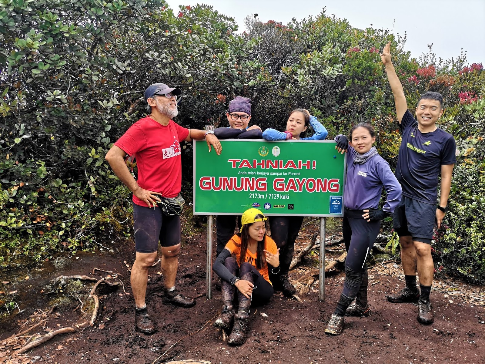
1250 Reach Mount Gayong (COT 1400)
With enough photos taken, we continued on and finally reached Simpang Proton, the junction leading towards Mount Junction(?) for Trans V2.
That part of the trek is barricaded, so turned right and you will reach Mount Gayong in about 5 minutes.
Mount Gayong at 12.50pm. Finally, mission accomplished! Or have we?
 |
| Simpang Proton |
 |
| Simpang Proton |
That part of the trek is barricaded, so turned right and you will reach Mount Gayong in about 5 minutes.
 |
| I was told it is Mount Junction behind me |
 |
| What a long journey for the V2 folks |
Mount Gayong at 12.50pm. Finally, mission accomplished! Or have we?
 |
| Mount Gayong |
 |
| We made it! |
 |
| Finally! |
Day 2 (Part 3): Down, down and down you go, back to where you started
1320 Leave Mount Gayong
We had our packed bacon fusilli on Mount Gayong after taking enough photos with the sign. Although I was already starving on my way to Mount Gayong, I could hardly finish my lunch since it turned cold and I was feeling tired. With about 20% of my lunch left, I joined the rest in descending.
1530 Reach Mount Korbu (5min break)
Most people was able to hike faster on their return journey, but not for me. Thankfully, at this point, I was still able to keep to the same pace and reached Korbu in 2 hours. I would be lying to say I didn’t feel exhausted by then as I had not been hiking a lot for the past 2 years. To counter the exhaustion, Terry and I counted the number of ladders along the way – 3 from Gayong to Korbu.
 |
| Back to Mount Korbu |
 |
| Look how muddy my clothes were |
1730 Reach Kem Botak
The descent from Mount Korbu is the most challenging part for me. As it was steep and full of ladders (we counted 21 from Mount Korbu to Kem Seroja), I couldn’t speed up and in the end took longer than expected to reach Kem Botak.
I reckon the rest was at least half an hour to an hour ahead of me. Knowing it’s better to preserve my energy in case I need to hike until nightfall I didn’t pursue the team but instead hike with comfortable pace.
1845 Reach Last Water Point
 |
| Back to Mount Korbu |
 |
| With the trail being so steep, I descended slowly |
1845 Reach Last Water Point
Thankfully the hike from Kem Botak to Last Water Point didn’t take too long and Terry and I reach before it turned dark. As his water ran out, he went down to the water fall for water while I took a short break to rest my legs. Wrong move, as the place was full of sandflies! Once Terry was back, we immediately left for fear of those merciless sandflies.
2000 Reach Kem Kijang
With my slow pace, we ended up hiking in the dark soon after we left last water point. The path didn’t gets any flatter as I remember complaining about the steepness and succumbing to my laziness, and wanting to give up. It was steep and dark and I was acting all cranky. We reach Kem Kijang at 8pm, almost 2 hours over our estimated time of arrival. We were joined by Uncle Mak who waited there for us, for fear of the two of us getting lost or worse, injured.
 |
| Poor folks waited for us at Kem Kijang until they got bored and left, leaving only Uncle Mak to continue waiting for us |
2120 Reach Kem Seroja, wash up, dinner, and rest
With his lead, we made it safely to Kem Seroja, something I was grateful for, as the path from Kem Kijang towards Kem Seroja could be confusing in the dark.
 |
| White pepper pig stomach soup for dinner |
We washed up at the river and sat down for a hearty bowl of white pepper pig stomach soup, perfect for the chilly night. With our stomach filled and utensils washed, we headed back to our tent to get our much needed rest. It’s been a long day, and a pretty tiring one.
Day 3 : It’s time to go home
The third day is the most relaxing of the entire trip and take only 3 hours maximum to get to the trail head. One can take their sweet time and only leave in the afternoon or leave early morning and have a nice lunch out there near Ipoh. Being a sucker for good food, of course we were the latter.
0820 Pack and Leave
 |
| Time to pack and leave |
We woke up as early as 7am and after breakfast, we packed and started descending from Kem Seroja. While the quick ones were able to speed off downhill, I was only able to hiked slowly considering the fact that I hadn’t been exercising regularly for a long time and the trail was quick steep. I could barely keep up to the others who were in front of me.
 |
| Leaving the jungle |
 |
| Bye KorGa |
1110 Reach trail head
After dragging myself slowly for three hours (and passing by 2 more ladders from Kem Seroja to Kem Balak), we finally reached the trail head where our cars were packed. We put our bags in the car, and walked to the river to wash up, before driving to Ipoh for lunch.
 |
| Set Lunch A in Restaurant Sun Marpoh |
Restoran Sun Marpoh
Address: 67-69, Jalan Lau Pak Khuan, Ipoh Garden, 31400 Ipoh, Negeri Perak, Malaysia
Opening hours: Thursday – Tuesday, 11:30am–3pm and 5:30–10pm
Coordinates: N4.611861, E101.107866
Epilogue
Having missed KorGa for numerous time, I was about to forget about doing these G7 peaks, but thankfully I was blessed with luck to finally tick them off the list.
Although it was raining season, we were blessed with 3 consecutive days of great weather. It only rained for a short while after we pitched up our tents on Day 1 and the other time was sunny.
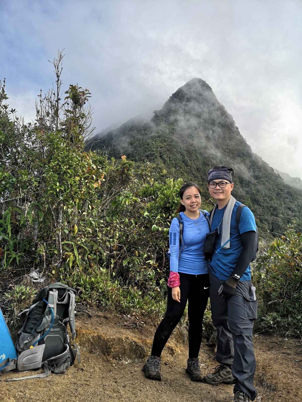 |
| The person who accompany me at all times, thank you :) |
The ascent was manageable but the descent via steep, slippery slope and shaky ladder killed the mood, and it's a tough mental struggle to keep pushing my lazy self ahead.
 |
| The fun team who were bubbly and lively, thank you :) |
With my current state, I could have just stopped at Korbu (man, that would be a lot easier), but I was glad I made it to Gayong as well. The thought of hiking for another 2 hours may not sound difficult, but that’s where the real challenge kicks in. After hours of hiking, we could easily burn out and that extra 2-3 hours does make a difference. Thank god, I did it!
 |
| Congratulations! |
Finally, mission accomplished and I can say sayonara 👋 to KorGa! *wink*
 |
| Uncle Mak, Yu Ai, Vindy and Zhan Yi together with Terry and I. We made it! |
My G7 milestone:
(G1) Tahan ✅ Sep 2016 (4D3N Merapoh-Merapoh)
(G2) Korbu ✅ Oct 2019 (3D2N Korga)
(G3) Yong Belar ✅ Feb 2017 (dayhike)
(G4) Gayong ✅ Oct 2019 (3D2N Korga)
(G5) Chamah ✅ May 2017 (3D2N)
(G6) Yong Yap
(G7) Ulu Sepat
My G10 milestone:
(G8) Batu Putih
(G9) Irau ✅ Aug 2019 (Trans Jerging dayhike)
(G10) Benum ✅ Mar 2017 (dayhike)
2 more to go for G7
3 more to go for G10
One at a time, let's tick them off my list! *wink*
---------------------------------------------------------------------------------------------------------------------------------------------------
Thank you for reading all the way till the end. Too much info and you just want a summarised itinerary but too lazy to scroll back up? Here’s a summary I’ve drafted up for you. Hope it helps you with your planning.
Itinerary
**Disclaimer: Below is my timing according to my speed. So please take it with a grain of salt, as everyone have different pace. Have fun hiking this mountain. *wink*
Day 1 (Ulu Kinta Dam > Kem Balak > Kem Seroja)
0945 Korga trail head
1150 Reach Kem Balak
1210 Leave Kem Balak
1315 Reach Kem Seroja
1700 Dinner and rest
Day 2 (Kem Seroja > Kem Kijang > Last Water Point > Kem Botak > Mount Korbu > Mount Gayong > return)
0430 Breakfast
---Ascent--- (7 hours)
0535 Start ascent
0700 Reach Kem Kijang
0800 Reach Last Water Point
0900 Reach Kem Botak (5min break)
1030 Reach Mount Korbu (10min break) (COT 1200)
1040 Leave Mount Korbu
1155 Reach Mossy Tree (5min photo session)
1250 Reach Mount Gayong (COT 1400)
-----Return---- (8 hours) – could be shorter for most people
1320 Leave Mount Gayong
1530 Reach Mount Korbu (5min break)
1730 Reach Kem Botak
1845 Reach Last Water Point
2000 Reach Kem Kijang
2120 Reach Kem Seroja, wash up, dinner, and rest
Day 3 (Kem Seroja > Kem Balak > Ulu Kinta Dam)
0700 Breakfast
0820 Pack and Leave
1110 Reach trail head
Points To Note
Total distance : ± 30km round trio
Total elevation gain : about 2400m in total
Duration (incl. breaks) : 10-12 Hours for fast hikers, 12-16 Hours for average hikers, 2D1N camping is recommended for slow hikers
Leech? : found near streams and Kem Balak, especially in raining season
Sandflies: found especially near Kem Kijang and Last Water Point
Must bring items : Headlights and spare batteries, sufficient food ration and water, first aid kid, jacket, and other camping essentials
Distance from Last Water Point to Gayong: average 5 hours one way, 10 hours return (so make sure you have enough to last that stretch)
---------------------------------------------------------------------------------------------------------------------------------------------------
-Thanks for reading-


Which was one harder? Korga or Benum?
ReplyDeleteI would say benum is harder, both as a dayhike and camping trip as the trail is more raw (when I visited), there is no clean water source, and the undulating trail is such a mood killer. But I didn't do Korga dayhike to have a better comparison, so I might be wrong
DeleteI find this very informative. Thank you for blogging. I have a few questions (1) You were cooking with a big pot at Kem Seroja. You brought it for the trip or it's available at the campsite? (2) During summit day, did you guys left your tents & bags at Kem Seroja? Was it safe?
ReplyDeleteThank you & belated congratulations :)
Hi DKJ, 1. we brought our own cooking pot 2. We left our camping bags in our tent. We only bring a small daypack, food, water and valuables, and necessary survival kit (waterproof jacket in case it rains, first aid kit, etc)
DeleteSecond time reading yr Korga hike, notice that yr G7 list, fr what i know(reading fr others blog) normally people do Chamah n Ulu Sepat at one go but it seem u did left out Ulu Sepat
ReplyDeleteAnyway, again an article full of excitement n useful info(the reason of me revisiting here), Thank You !!
Very interesting to read out till the ending. Such a good experience to hike on both i.e. Korga. Btw, I'm actually on solo hikers.
ReplyDeleteHii.. nak tny, macam mana u handle pacat ye? U geli x dgn pacat or ok je? Slh 1 benda yg i lemah bila hiking selain tangga sebab gayat, i geli pacat juga..huhu
ReplyDelete